A resource for reliable information about significant people, places, events, and things in Minnesota history.

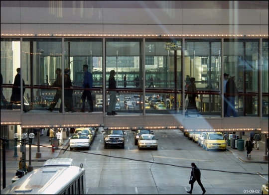
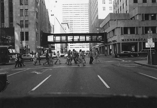
Skyway over Sixth Street, Minneapolis, 2002.
In 1962, a local real estate developer named Leslie Park and architect Ed Baker built a covered walkway over Marquette Avenue in downtown Minneapolis. Park's structure would later be known as a skyway. It was the first link in a system that later spread throughout much of the city's downtown.
As one of the downtown's major property owners, Park had been concerned about the postwar suburban boom and its impact on the city's historic central business district. In 1955, General Mills, one of Minneapolis's premier companies, moved out of downtown to a new campus in Golden Valley. The next year, the Southdale Shopping Center opened in what had been a suburban cornfield.
In the mid-1950s, in an effort to revitalize the city's retail core, Park began promoting his covered walkway idea. Initially, he encountered skepticism from other business owners. Some felt that his plan would cut into street-level retail activity.
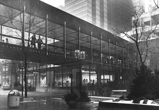
Park was able to test his plan in 1959, when his Baker Properties began designing the Northstar Center at Seventh Street and Marquette Avenue. As part of the design, Park included a pedestrian bridge spanning Marquette Avenue. The bridge linked his new development to the Northwestern National Bank building across the street.
Park's creation, the city's first skyway, soon proved to be a great success. Downtown office workers and visitors found that they could be protected from the extremes of Minneapolis weather as they moved from building to building.
Slowly, the skyway system began to grow. Additional links were added in the blocks surrounding the Northstar Center, including another skyway built by Park that opened on June 12, 1963. It spanned Seventh Street, connecting the Northstar Center with the Roanoke Building. (Park's pioneering 1962 skyway was eventually demolished to make way for the new Norwest Bank tower, later named for the bank's successor, Wells Fargo.)
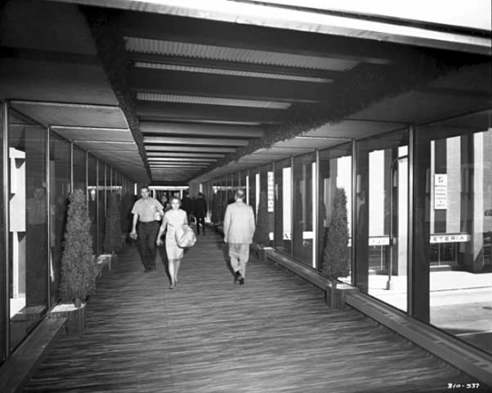
Because each new skyway was privately developed by adjoining property owners, the system grew in an ad hoc fashion with no uniformity or consistency of design. Early on, the pedestrian bridges connected buildings that were already in place, so connections across downtown streets were often awkward. In some cases, the interior passageway on one side of the street was at a higher level than the one on the other side, so skyway users had to go up or down stairs to get from one building to the other. Often, there were twists and turns through narrow interior hallways that were not intended for the masses of pedestrians generated by the new climate-controlled walkways.
By 1972, seven skyways were in use in the downtown core, but not all seven were interconnected. In the next year, the IDS Center on Nicollet Avenue was completed. It was the first major downtown development designed to accommodate skyway connections on all four of its sides. The building's strategic location enabled it to connect the skyways in the Marquette office district with those serving the retail stores along Nicollet.
When the city's eighth skyway opened in November 1972, the Tribune noted that Minneapolis was gaining a national reputation as a "second story city." Soon, small stores and restaurants, geared to the heavy foot traffic, began to appear along the second-story corridors connecting the skyways. Second-floor rents increased sharply. Often, they equaled ground-floor rents.
By mid-1974, with all four IDS skyways in place, the system had connected eight downtown blocks from Fifth to Ninth Streets and from Nicollet to Second Avenue South.
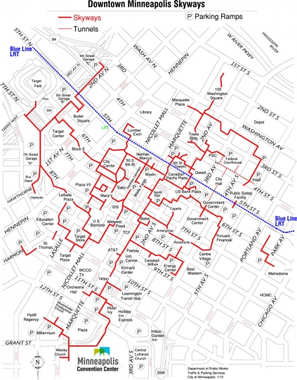
Building on the success of Leslie Park's 1962 experiment, the system continued to grow over the next fifty years. By the early twenty-first century, Minneapolis had the world's largest skyway system, connecting eighty blocks through a network of walkways extending over eight miles.

Kaufman, Sam H . The Skyway Cities. Minneapolis: CSPI, 1985.
Millett, Larry. AIA Guide to the Twin Cities: the Essential Source on the Architecture of Minneapolis and St. Paul. St. Paul: Minnesota Historical Society Press, 2007.
Nathanson, Iric. Minneapolis in the Twentieth Century: The Growth of an American City. St. Paul: Minnesota Historical Society Press, 2010.
Podolske, Richard C. "Skyways in Minneapolis/St. Paul: Prototypes for the Nation?" Submitted for presentation at Planning 75: Innovation and Action, October 25–29, 1975.
 |
 |
 |
 |
 |
 |
 |
 |
 |
The IDS Center—the first major downtown development designed to support skyway connections on all four of its sides—opens in 1974. The Center's strategic location enables it to connect the skyways in the Marquette Avenue office district with those serving the retail stores along Nicollet Avenue.
General Mills, one of downtown's major employers, moves to a new suburban campus in Golden Valley.
Southdale Center, the country's first enclosed, climate-controlled shopping center, opens in what had been a suburban cornfield.
Leslie Park designs his Northstar Center at Seventh Street and Marquette Avenue. His design includes a covered walkway spanning Marquette.
Minneapolis' first skyway opens. It connects the Northstar Center with the Northwestern National Bank building across the street.
The IDS Center is completed. It is the first major downtown development designed to support skyway connections on all four of its sides.
Skyways connect eighty downtown blocks. The Minneapolis skyway network is the largest system of its type in the United States.
Made possible by the Arts and Cultural Heritage Fund through the vote of Minnesotans on November 4, 2008. Administered by the Minnesota Historical Society.
Minnesota Historical Society • 345 W. Kellogg Blvd., St. Paul, MN 55102-1906 (Map) • 651-259-3000 © MNHS.
Send questions or comments to mnopedia![]() mnhs [dot] org. View our Privacy Policy.
mnhs [dot] org. View our Privacy Policy.