A resource for reliable information about significant people, places, events, and things in Minnesota history.

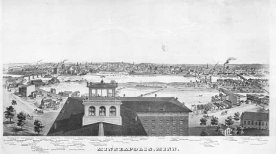
View of Minneapolis from An Illustrated Historical Atlas of the State of Minnesota, 1874.
When Alfred T. Andreas chose Minnesota as the subject for his new atlas, the state was only fifteen years old. Andreas's publication of An Illustrated Historical Atlas of the State of Minnesota changed the way state atlases were written, illustrated, and distributed. The atlas also put the social and cultural landscape of early Minnesota literally on the map.
Andreas was born in upstate New York in 1839 and moved to Iowa probably sometime in the 1850s. Back in Iowa after the Civil War, he was recruited to join a county mapping company. While selling maps, Andreas began to consider a new format. He believed that he could find new buyers for county maps that were separated by township and bound in book form.
In 1873, Andreas set out to create an atlas that would cover the entire state of Minnesota. An Illustrated Historical Atlas of the State of Minnesota, published the following year, would be the greatest success of his career. The atlas was the first in a new genre that combined maps of an entire state with detailed information about particular locations. Andreas would go on to publish other state atlases and histories. However, none were as commercially successful as the Minnesota project.
Creating a new type of atlas proved a challenge to Andreas's map publishing company. When he began the project in 1873, most of the state was still unmapped. Many areas of Minnesota were sparsely populated and travel was often difficult. From his Chicago offices Andreas directed a group of over 100 employees who traveled Minnesota to work on the atlas.
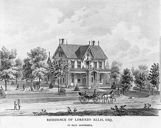
As teams of mapmakers and artists created the maps and lithographs for the atlas, teams of salesmen convinced Minnesotans to subscribe. Fifteen dollars would buy a subscription and add the subscriber's name to the atlas. But Andreas's salesmen also convinced subscribers to pay for the publication of portraits and biographies. They also encouraged subscribers to include images of their homes, families, or farms. By the time the process was complete, the team had collected 12,000 subscriptions.
Andreas relied on advertising more than previous map publishers did. He took out printed atlas advertisements in local newspapers. Andreas also encouraged the newspapers to print stories about the project. The newspaper articles were primarily aimed at Minnesota's wealthy farmers and boasted about the size, scope, and importance of the atlas project.
The atlas was published in 1874 at a cost of more than $200,000. The production of the atlas took seventy tons of paper and seventeen tons of cardboard binding. The finished 400-page atlases included nearly 100 pages of maps and over 100 pages of illustrations. The volume also contained historical and geographical information about the state. Most important to many subscribers, the atlas contained a thirty-page list of "Patrons." A poor wheat harvest meant that only around 10,000 of 12,000 subscribers were able to pay to collect their atlases. Nevertheless, historians estimate that one in seven Minnesota households had a copy.
Andreas's project was not without criticism. Some accused Andreas and his team of being swindlers. They argued that Andreas took advantage of farmers and laborers. The traveling salesmen, they claimed, convinced humble citizens to spend money they could not afford. However, what made the atlas seem like a scheme to many was a major part of its appeal. Previous atlases and maps had illustrated only major institutions and the homes of the rich. Andreas's atlas encouraged ordinary citizens to pay to have their home or farm sketched. It allowed farmers and doctors to appear alongside more illustrious Minnesotans. To some, the atlas company employees seemed no different from travelling peddlers selling cheap trinkets and patent medicines. To others, the atlas seemed to promise a more democratic view of Minnesota.
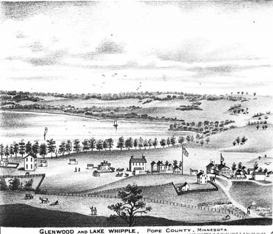
In the end, the maps printed in An Illustrated Historical Atlas of the State of Minnesota were low quality. However, the atlas continues to provide researchers with a wealth of social and cultural information about early Minnesota. Its illustrations depict towns, structures, and landscapes in great detail. The atlas emphasizes not only Minnesota's geography, but its history and future potential. Alfred T. Andreas's atlas put a young state on the map and continues to serve as a rich historical record of early Minnesota.

Conzen, Michael P. "Maps for the Masses: Alfred T. Andreas and the Midwestern County Atlas Map Trade." In Chicago Mapmakers, edited by Michael P. Conzen, 47–63. Chicago: Chicago Historical Society, 1984.
Lanegran, David A. Minnesota on the Map: A Historical Atlas of Minnesota. St. Paul: Minnesota Historical Society Press, 2008.
Ristow, Walter W. "Alfred T. Andreas and his Minnesota Atlas." Minnesota History 40, no. 3 (Fall 1966): 120–129. http://collections.mnhs.org/MNHistoryMagazine/articles/40/v40i03p120-129.pdf
 |
 |
 |
 |
 |
 |
 |
In 1874, Alfred T. Andreas publishes his 400-page Illustrated Historical Atlas of the State of Minnesota.
Alfred T. Andreas is born in upstate New York.
Andreas is hired to work for a county mapping company.
Andreas begins work on his comprehensive historical atlas of Minnesota.
An Illustrated Historical Atlas of the State of Minnesota is published at a cost of over $200,000. However, a poor harvest and financial difficulties mean that many of his subscribers cannot afford to pay.
Made possible by the Arts and Cultural Heritage Fund through the vote of Minnesotans on November 4, 2008. Administered by the Minnesota Historical Society.
Minnesota Historical Society • 345 W. Kellogg Blvd., St. Paul, MN 55102-1906 (Map) • 651-259-3000 © MNHS.
Send questions or comments to mnopedia![]() mnhs [dot] org. View our Privacy Policy.
mnhs [dot] org. View our Privacy Policy.