Manito gizhigans (spirit little cedar tree)

Manito gizhigans (spirit little cedar tree)

A white cedar tree sacred to the Ojibwe and known as manito gizhigans (spirit little cedar tree) on Grand Portage Bay, ca. 1965.

Dedication of Grand Portage National Historic Site

Dedication of Grand Portage National Historic Site

Assistant Secretary of the Interior Dale Doty, Mrs. Dale Doty, Ed Wilson, R. F. Lee, and Mike Flatte (seated) at Grand Portage’s national historic site dedication. Photograph by Abbie Rowe, August 9, 1951.

Grand Portage Bay

Grand Portage Bay

Grand Portage Bay, ca. 1920. Photograph by Gallagher Studio.

Bird’s-eye view of the reconstructed Grand Lodge on Grand Portage Bay

Bird’s-eye view of the reconstructed Grand Lodge on Grand Portage Bay

Bird’s-eye view of the reconstructed Grand Lodge on Grand Portage Bay, ca. 2010s. Photograph by the National Park Service.

Map of Native American land cessions in the present-day state of Iowa

Map of Native American land cessions in the present-day state of Iowa

Map by Charles C. Royce titled “Indian Land Cessions in the United States, 1784–1894.” Public domain.

Map of Native American land cessions in the present-day state of Minnesota

Map of Native American land cessions in the present-day state of Minnesota

Map showing land cessions made by Native Americans in the present-day state of Minnesota between 1784 and 1894.

Detail of a map of land claimed by France for King Louis XV

Detail of a map of land claimed by France for King Louis XV

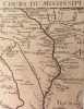
Detail of a map of land claimed by France for King Louis XV and the route of the Mississippi River (Carte de la Louisiane et du cours du Mississippi), 1718. Map by Guillaume de L'Isle, published by Chez l'Auteur. The map shows three French fur trading forts, labeled “Vieux forts,” just below the label “Saut de S. Antoine” (S.t Anthony Falls, Minneapolis). Two of them were likely trading posts built by Le Sueur (1695 and 1700). The third remains a mystery. Ten years later a fourth fort would be built at the site of Frontenac. The Root River is listed as “R. aux Ecors.” The Prairie du Chien area is at the mouth of the Wisconsin River, listed as “Ouisconsing R.” From this river to the west is the “Chemin des Voyageurs”—the Voyageurs’ Trail—ending at a large “Aiaouez” (Ioway; Bahkhoje) village whose residents traded buffalo products and pipestone with Europeans. From the maps collection of the MInnesota Historical Society, St. Paul (G3700 1718 .L5 Reserve 4F).

Hay-nee-ah-cha (Soaking Mountain, also known as Trempealeau Mountain)

Hay-nee-ah-cha (Soaking Mountain, also known as Trempealeau Mountain)

Hay-nee-ah-cha (Soaking Mountain, also known as Trempealeau Mountain), Trempealeau Bay, Mississippi River. Photograph by Grant Pavek, date unknown. Used with the permission of Grant Pavek.

Jefferson Highway, Itasca State Park

Jefferson Highway, Itasca State Park

Jefferson Highway inside Itasca State Park, ca. 1930.

Source of the Mississippi River, Itasca State Park

Source of the Mississippi River, Itasca State Park

Source of the Mississippi River, Itasca State Park, ca. 1920.

Pages

Subscribe to RSS - Environment