A resource for reliable information about significant people, places, events, and things in Minnesota history.

This c. 1860 photo shows the west face of Barn Bluff as viewed from the Wisconsin shore of the Mississippi River. Much of the lower portion of the bluff was removed in 1960 for construction of a highway bridge.
Roughly ten thousand years ago, raging glacial meltwaters created the broad valley of the Upper Mississippi River that we know today. They also helped form one of the river’s most famous and significant landmarks, known in Dakota as He Mni Caŋ (Hill Water Wood) and in English as Barn Bluff.
As the last ice age came to an end, the glaciers melted. Glacial Lake Agassiz was formed from melt water. From Minnesota, the lake extended far into Canada, was more than 600 feet deep, and covered an area larger than the present-day five Great Lakes combined. As melting continued, the enormous body of water broke free and, joined by other melt waters began racing south and east through central Minnesota as glacial River Warren. This river, and others like it during the Pleistocene, carved the path of the present-day Minnesota River, merging it with another smaller river, the Mississippi.
Over time, the combined water mass eventually carved the broad valley of the Mississippi. As the meltwaters approached the future site of Red Wing, they bulldozed paths around and through the ancient limestone formations of the area. Stronger rock was left behind, including the formation later known as He Mni Caŋ and Barn Bluff.
Thousands of years passed. American Indians of the Woodland period lived in communities some five miles from the high limestone bluff. Dakota people gave it the name He Mni Caŋ (Hill Water Wood) to reflect the way it appeared to be rising from the water. In the late 1600s, Frenchmen exploring their nation’s claims in “New France” traveled along the Upper Mississippi. They encountered the river bluff. To them it appeared like a barn, so they named it “La Grange” (the barn).
Tatanka Mani, the Mdewakanton Dakota war leader, brought his small band of followers near the foot of He Mni Caŋ around 1815. Tatanka Mani, “Walking Buffalo” in English, was also known as Red Wing. He allied himself with the United States during the War of 1812. After the war, Americans moving up the Mississippi stopped at Red Wing’s village. Many visitors climbed to the top of the river bluff to enjoy the view, a broad vista that included the glacial river valley and the Mississippi. Americans anglicized the French name to Barn Bluff.
Following the 1851 Treaty of Mendota, the Red Wing band of Mdewakanton, now led by Wacouta, reluctantly left their homes. They took up residence on a Minnesota River reservation near present-day Morton.
Bluff climbers still scaled the now-well-known promontory, but its heights served another important purpose. Territorial Minnesota was largely cut off from the rest of America when the Mississippi froze each winter. Isolated settlers impatiently awaited the thaw and arrival of riverboats. Lookouts stood atop Barn Bluff each spring watching for steamboat smoke on the horizon. The appearance of the first steamer was an important day.
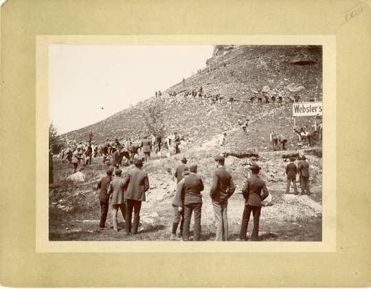
In the 1870s, the new railroads required stone “rip rap” to protect rail lines from erosion. The main tracks between Chicago and St. Paul ran past Barn Bluff, so it became a source of the rock. Workers blasted tons of stone from the limestone hill. The bluff’s quarries, along with those of other nearby sites, also provided stone for buildings in Red Wing and elsewhere. Kiln operators on the bluff “burned” limestone, reducing it to lime that, when mixed with sand and water, produced a kind of cement. Thanks to Barn Bluff and its neighboring hills, Red Wing became known as Minnesota’s “Lime Center.”
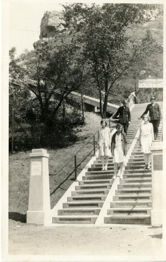
By 1907, some Red Wing citizens worried that the scenic but now scarred Barn Bluff would be blasted to bits. A concerted effort produced enough money to buy the bluff in 1910. Ownership went to the city. In 1929 the local Kiwanis Club built a stairway to the summit to more easily enjoy the view.
Nearly fifty years later, Barn Bluff came under a new threat. U.S. Highway 61 needed to be re-routed and the old 1895 wagon bridge to Wisconsin was to be replaced. These badly needed improvements were made, but at a heavy cost. Barn Bluff lost a large slice from its south-facing side and a significant portion of its northern face adjacent to downtown Red Wing. Blasting destroyed most of the original stairway, but a number of its concrete steps were saved. They were reinstalled and augmented in 1983 when the Kiwanis Noontime Club led a new effort to create a staircase to the bluff top.
A public park since 1910, the ancient bluff serves as an impressive landmark. An old quarry road, the improved stairway, and resting places make the hike to the summit relatively safe and easy.

Angell, Madeline. Red Wing, Minnesota: Saga of a River Town. Minneapolis: Dillon Press, 1977.
Bluemle, John P. “Glacial Lake Agassiz,” North Dakota Geological Survey. North Dakota State Government website, May 9, 2007.
https://www.dmr.nd.gov/ndgs/ndnotes/agassiz/
Bray, Edmund C. Billions of Years in Minnesota: The Geological Story of the State. St. Paul: Science Museum of Minnesota, 1967.
———. “The Ice Age Sculpted Goodhue County,” Goodhue County Historical News 10 (February 1976): 5–6.
Browning, Dan. "Red Wing Residents, Tribal Members Find Common Ground on He Mni Can." Minneapolis Star Tribune, October 20, 2018.
http://www.startribune.com/red-wing-residents-tribal-members-find-common-ground-on-he-mni-can/498111871/
Curtiss-Wedge, Franklyn. History of Goodhue County, Minnesota. Chicago: H.C. Cooper, Jr. & Co., 1909.
History of Goodhue County. Red Wing: Wood, Alley & Co., 1878.
Johnson, Frederick L. Goodhue County, Minnesota: A Narrative History. Red Wing: Goodhue County Historical Society, 2000.
———. Red Wing: A Portable History. Red Wing: City of Red Wing Heritage Preservation Commission, 2007.
Madigan, Thomas. “The Geology of the MNRRA Corridor,” in River of History: A Historic Resources Study of the Mississippi National River and Recreation Area. Hemisphere Field Services, Inc. National Park Service website, accessed July 18, 2012.
http://www.nps.gov/miss/historyculture/upload/River_Ch_1.pdf
Posey, Chessley J. “Geographical Influences in the Exploration and Early Development of Minnesota.” Journal of Geography 14 (February 1916): 214–217.
———. “The Influence of Geographic Factors in the Development of Minnesota.” Minnesota History 2 (August 1918): 443–453.
Sansome, C.J. “Goodhue County’s Geologic Story.” Goodhue County Historical News 10 (February 1976): 1–2.
Schmidt, Edward W. “Geological Ages,” in Franklyn Curtiss-Wedge, History of Goodhue County, Minnesota. Chicago: H.C. Cooper, Jr. & Co., 1909.
Upham, Warren. “Glacial and Modified Drift of the Mississippi Valley from Lake Itasca to Lake Pepin.” Bulletin of the Minnesota Academy of Science/em> 4 (December 1905): 272–299.
 |
 |
 |
 |
Meltwaters from the final stage of the Ice Age about 10,000 years ago carve through limestone formations in the future Red Wing area. They create an island in the glacial river that becomes present-day He Mni Caŋ (Barn Bluff.
Meltwaters stored in sprawling glacial Lake Agassiz break free and begin flowing along the path of the future Minnesota and Mississippi River valleys.
After more than 2,000 years, the glacial river flow subsides and the vast river valley created by the surging waters gradually begins to fill. He Mni Caŋ, a one-time island in the glacial river, is left standing.
Frenchmen exploring their nation’s claims in “New France” discover a barn-shaped river bluff along the Upper Mississippi. They name the promontory “La Grange” (the barn).
Mdewakanton Dakota war leader Tatankamani (also known as Red Wing) and his band build a village near the foot of He Mni Caŋ.
Following the 1851 Treaty of Mendota, the Mdewakanton reluctantly leave their river and bluff-side homes for a Minnesota River Valley reservation.
Barn Bluff becomes a major source of lime and stone for the next thirty-seven years. Red Wing is nicknamed Minnesota’s Lime Center.
Mining operations on Barn Bluff deface the Red Wing landmark prompting civic leaders to begin an effort to preserve it.
The city of Red Wing purchases Barn Bluff from private interests and halts stone and lime operations there.
Red Wing Kiwanis Club leads an effort to build a stairway to Barn Bluff’s summit, making it easier for visitors to enjoy the famous view.
U.S. Highway 61 needs to be improved and widened near Red Wing while the aging 1895 bridge over the Mississippi requires replacement. Crews blast away parts of the northern and western faces of the bluff and the Barn Bluff stairway.
Red Wing’s Kiwanis Noontime Club leads the effort to create a new staircase to the bluff top, making Barn Bluff more accessible again for visitors.
Made possible by the Arts and Cultural Heritage Fund through the vote of Minnesotans on November 4, 2008. Administered by the Minnesota Historical Society.
Minnesota Historical Society • 345 W. Kellogg Blvd., St. Paul, MN 55102-1906 (Map) • 651-259-3000 © MNHS.
Send questions or comments to mnopedia![]() mnhs [dot] org. View our Privacy Policy.
mnhs [dot] org. View our Privacy Policy.