A resource for reliable information about significant people, places, events, and things in Minnesota history.
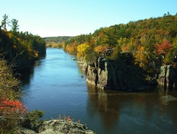
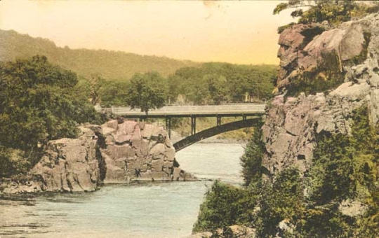
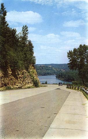
The Dalles of the St. Croix River seen from the Wisconsin bank, July 2, 2009.
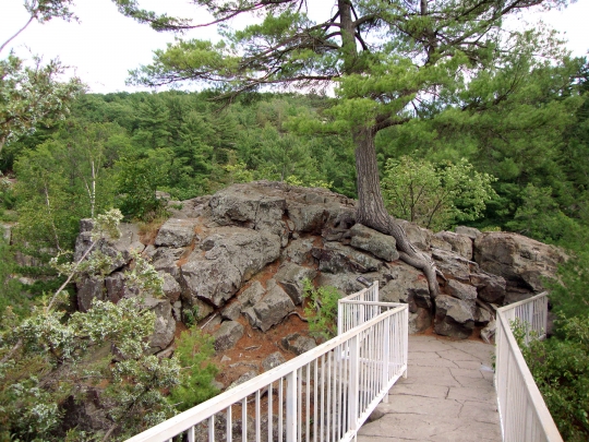
The Interstate State Park, located on 295 acres in Taylors Falls, is the second-oldest state park in Minnesota. Created in 1895, its unique topography and geological history draw many visitors to the area. It is the first park in the United States to be located in two states, Minnesota and Wisconsin, with the St. Croix River serving as the border. The two parks are operated separately by the states’ Departments of Natural Resources.
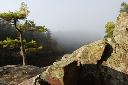
Over one billion years ago, basaltic lava flowed out of the earth to form thick layers of the black rock found along the St. Croix River near Taylors Falls. More than 500 million years ago, an ocean ebbed and flowed over the area, depositing rocks and sea life and creating fossils. Deposits of ocean silt and sand formed shale and sandstone.
Finally, ten thousand years ago, a much larger Glacial St. Croix River, fed by Glacial Lake Duluth, carved out the current river valley by gradually breaking up and eroding the basalt lava flows to create the 100-foot-tall vertical cliffs lining the river. Ten distinct lava flows, more than ten feet thick, exist along the Minnesota side of the river. The area where the river turns and runs through a narrow gorge was named the Dalles of the St. Croix by French explorers. Dalles, in French, means flagstone or slab of rock.
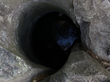
The park’s most famous features are its potholes, which are recognized as the world's deepest and most numerous (over 400) relative to their area. They are located in the area of the park once called the Glacial Gardens. Powerful glacial waters carried and swirled rocks, pebbles, and boulders that created depressions in the hard basalt. When trapped in the low spots, the swirling water and abrasive materials created deeper and deeper depressions that gradually became potholes.
The potholes vary in size and depth. Some have fanciful names, such as bottomless pit, bake oven, devil’s parlor, hourglass, and devil’s alcove. The bottomless pit’s dimensions are twelve to fifteen feet wide and sixty feet deep. Additional potholes, filled with silt, sand, and other debris, await discovery and excavation.
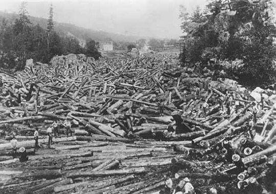
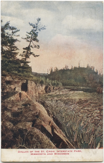
On June 13, 1886, a series of events led to what may be the largest recorded logjam in the world. Winter logging and a dry spring led to low water in the rivers and delayed transporting the logs to the sawmills. When heavy rain caused the rivers to rise, thousands of logs, dumped into the rivers that fed the St. Croix, led to a two-mile-long logjam at the Dalles.
An estimated 125 to 150 million board feet of logs stuck in the narrow river gorge. It was made even worse by the ninety-degree turn in the river at Angle Rock. Two hundred men labored over six weeks to break up the jam using horses, steam engines, steamboats, dynamite, poles, and axes. This event boosted the local economy due to the thousands of visitors watching the activities and the lumberjacks spending their paychecks.
In the late 1800s, several concerned citizens began to lobby the public and legislators to create a state park in the Dalles area. Official protection, they argued, would preserve its natural beauty and deter neglect, vandalism, and logging. In the spring of 1896, a series of lectures promoted the park and described the history of the Dalles area and its potential. Lecturers included the state botanist and geologist. George H. Hazzard, an active park advocate, was appointed as its first superintendent.
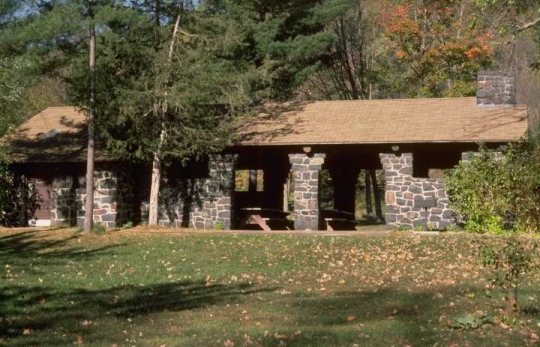
In the 1930s, workers in the WPA (Works Projects Administration) and CCC (Civilian Conservation Corps) built structures in two areas of the park: Glacial Gardens and the campground. Both are now on the National Register of Historic Places. The design of the structures, defined by the National Park Service as rustic style, features native materials such as basalt quarried from the area. Rustic-style architecture is labor intensive, finely crafted, and uniquely American. The original structures included a sanitation building, picnic shelter, shelter/refectory, drinking fountains, rest rooms, stone curb, retaining wall, and combination building (rest rooms, laundry, kitchen, utility).
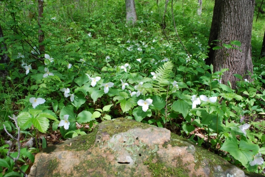
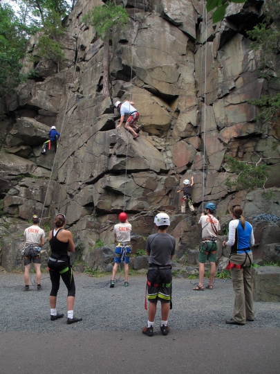
Visitors to the park enjoy geocaching, birding, picnics, kayaking, canoeing, hiking, camping, organized park tours, boat tours, and exploring for wildflowers and diverse flora and fauna. Rock climbing on the basalt cliffs is a popular challenge.

Anderson, Rolf T. Final Report: Minnesota State Park CCC/WPA Rustic Style Historic Resources. [MN: N.p.], 1988.
CCC/WPA Rustic Style Campground, Interstate State Park, National Register of Historic Places Registration Form.
http://focus.nps.gov/nrhp/AssetDetail?assetID=5b0e45ba-0f5e-4a24-95d3-56e856d8b302
CCC/WPA Rustic Style Historic District. Interstate State Park. National Register of Historic Places Registration Form.
http://npgallery.nps.gov/pdfhost/docs/nrhp/text/89001664.pdf
Crawfod, David, et al. Geology of Interstate Park, The St. Croix Dalles, Home of the World’s Deepest Potholes. [MN]: Minnesota Department of Natural Resources, 2009.
http://files.dnr.state.mn.us/destinations/state_parks/interstate/interstate_geology.pdf
Curry, Edna. Minnesota Department of Natural Resources. “The Greatest Logjam Ever!” Minnesota Volunteer 49, no. 288 (September–October 1986): 14–20.
http://webapps8.dnr.state.mn.us/volunteer_index/past_issues/article_pdf?id=563
Federal Writers' Project Guide to 1930s Minnesota. The WPA Guide to Minnesota. St. Paul: Minnesota Historical Society, 2002.
Hazzard, George H., comp. Lectures, Laws, Papers, Pictures, Pointers: Interstate Park; Dalles of the St. Croix; Taylors Falls, Minn., St. Croix Falls, Wis. St. Paul: [Rich and Clymer], 1896.
https://babel.hathitrust.org/cgi/pt?id=umn.319510020643732
Minnesota State Department of Natural Resources. Interstate State Park.
http://www.dnr.state.mn.us/state_parks/interstate/index.html
Minnesota State Department of Natural Resources. Interstate State Park Management Plan, February, 2009.
http://files.dnr.state.mn.us/parks_recreation/mgmtplans/interstate_plan.pdf
National Park Service. Saint Croix National Scenic Riverway WI, MN.
https://www.nps.gov/sacn/index.htm
Ojakangas, Richard W. Roadside Geology of Minnesota. Missoula, MT: Mountain Press Publishing Company, 2009.
SD1IN a1
"Last Notice" flier
3D Objects Collection, Minnesota Historical Society, St. Paul
Description: Paper flier created on May 7, 1913, to address the issue of banning cows from Interstate State Park.
http://collections.mnhs.org/cms/display.php?irn=10467010
St. Paul and Duluth Railroad Company. A Few Notes Regarding Inter-State Park and Dalles of the St. Croix River, 1899. [St. Paul]: St. Paul and Duluth Railroad Company, 1899.
Wisconsin Department of Natural Resources. Wisconsin State Park System.
http://dnr.wi.gov/topic/parks/name/interstate/
 |
 |
 |
 |
 |
 |
 |
 |
 |
 |
 |
 |
 |
 |
 |
 |
 |
 |
In 1895, the Minnesota legislature creates the State Park of the Dalles of St. Croix.
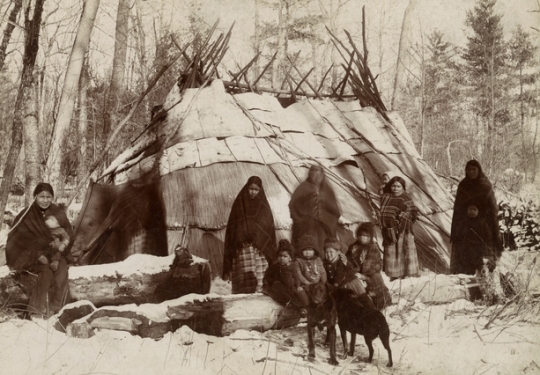
Early humans live in the St. Croix River Valley.
The French explorer Daniel Greysolon, Sieur Du Lhut, explores the St. Croix River area.
The area in and around the park becomes a major logging center.
An estimated 125 to 150 million feet of logs clog the narrow St. Croix River gorge. Many tourists come to see the logjam, adding to the economy of the Taylors Falls area. It takes six weeks and two hundred men to break up the jam.
The Minnesota legislature establishes the State Park of the Dalles of St. Croix.
Lectures given in the spring by Frank Nutter, E. E. Edwards, Warren Upham, Henry Osborn, and Conway MacMillan publicize the park’s natural history and potential.
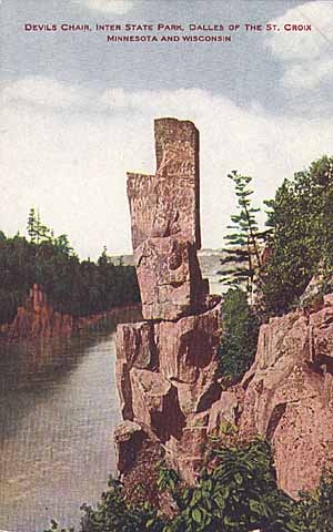
A promotional railroad brochure lists the following pothole names and park rock formations—St. Croix fireplace, devil’s chair, kitchen, sitting room, pulpit, cross, old man of the Dalles, gopher, two-faced man, and eagle nest point.
The Wisconsin legislature establishes the Interstate Park, on the east side of the St. Croix River.
George H. Hazzard, Interstate Park Superintendent, issues a notice banning cattle from the site. The notice issued, in part, due to complaints by the public about soiled clothes and shoes and that women and children were afraid of the cattle.
An average of ten thousand people visit the park on Sundays.
327,496 people visit the park.
To preserve its natural state, the U.S. Congress includes the St. Croix River in the National Wild and Scenic River Program.
The park structures built by the CCC/WPA are added to the National Register of Historic Places.
Vandals, who were never caught and prosecuted, destroy the thirty-foot Devil's Chair natural basalt structure using crowbars and hydraulic equipment.
Made possible by the Arts and Cultural Heritage Fund through the vote of Minnesotans on November 4, 2008. Administered by the Minnesota Historical Society.
Minnesota Historical Society • 345 W. Kellogg Blvd., St. Paul, MN 55102-1906 (Map) • 651-259-3000 © MNHS.
Send questions or comments to mnopedia![]() mnhs [dot] org. View our Privacy Policy.
mnhs [dot] org. View our Privacy Policy.