- Membership |
- Shop |
- Calendar |
- Donate
A resource for reliable information about significant people, places, events, and things in Minnesota history.
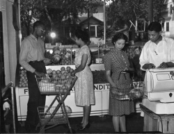
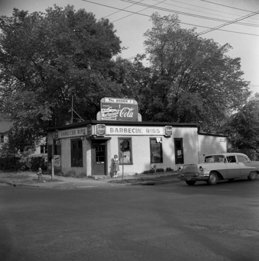
Interior of the Credjafawn Co-op Store, 678 Rondo Avenue, St. Paul, ca. 1950.
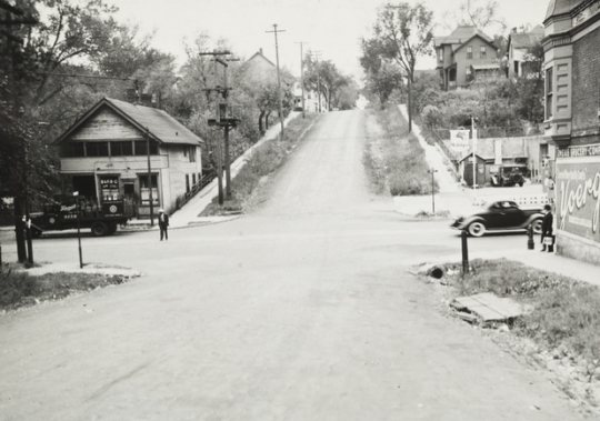
St. Paul’s Rondo neighborhood ran roughly between University Avenue to the north, Selby Avenue to the south, Rice Street to the east, and Lexington Avenue to the west. African American churches, businesses, and schools set down roots there in the late nineteenth and early twentieth centuries, creating a strong community. Construction of Interstate-94 (I-94) between 1956 and 1968 cut the neighborhood in half and fractured its identity as a cultural center.
From the beginning, Rondo was a haven for people of color and immigrants. Its namesake, Joseph Rondeau, moved there in the late 1850s from a site close to Fort Snelling, where he had faced discrimination due to his wife’s mixed white and indigenous heritage. French Canadian immigrants followed Rondeau to the area in the late nineteenth century; later, German, Russian, Irish, and Jewish families found homes there.
Beginning in the 1910s and 1920s, Rondo experienced a social and cultural boom. Music and theater flourished. African American newspapers such as the Appeal, the Northwestern Bulletin, and the St. Paul Recorder represented Rondo’s interests and needs. In 1913, St. Paul established its chapter of the NAACP, making it a center for civil rights activity. One member of the chapter, Rondo resident Roy Wilkins, later led the national NAACP.
As Rondo’s Jews advanced economically in the first decades of the twentieth century, they moved to new areas. This left behind affordable housing for African Americans. By the 1930s, half of St. Paul’s black population lived in Rondo. Even during the Jim Crow era, blacks and whites mixed relatively freely; interracial dating and even marriage sometimes took place.
Supported by the booming railway industry and local businesses, Rondo’s black families were upper-middle and middle class as well as working class. Integrated schools, such as Central High School, Maxfield Elementary School, and parochial schools, created a relatively high level of education and literacy among minority residents. This openness in turn attracted southern blacks who faced stark racial prejudice and violence.
Several organizations arose to meet the growing community’s social needs. The Hallie Q. Brown House (later renamed the Hallie Q. Brown Community Center) provided social services and gave African Americans a place to meet and socialize. In 1928, the Credjafawn Social Club began to offer a social and recreational space for young blacks. It went on to create a food cooperative and a credit union that helped residents finance their homes and educations. The Sterling Club, founded in 1919, was a networking association for African American professionals who were often excluded from other professional groups.
In the 1930s, commuters and city planners began to call for a highway linking the business districts of downtown St. Paul and Minneapolis. After World War II, city engineers chose St. Anthony Avenue as the route. This street was located between University Ave and Marshall Avenue, and went all the way to Minneapolis. When the Federal Aid Highway Act of 1956 promised funding, it set in motion plans to lay down the freeway through the heart of the Rondo area.
Resistance to the freeway plan came quickly. In early 1956, Reverend Floyd Massey Jr. and Timothy Howard started the Rondo–St. Anthony Improvement Association. This group, speaking for threatened property holders, protested the proposed route and pushed for assistance for those forced to move.
The Housing Authority offered to help if the Highway Department would pay $30,000 to cover costs, but ultimately contributed no funds. The St. Paul City Council rebuffed attempts at passing local open-occupancy laws. The association did, however, succeed in changing the interstate’s design from an elevated to a depressed highway with bridges joining the bisected sides, dividing the community in a less pronounced way.
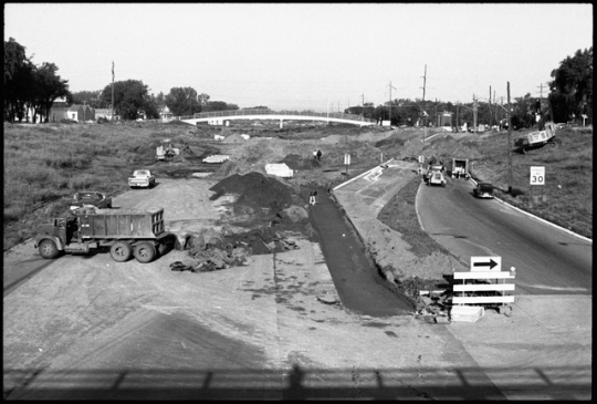
In September of 1956, when construction began, some Rondo residents continued to resist. Police forcibly removed Reverend George Davis from his home when he refused to evacuate and make way for wrecking crews. Construction proceeded, however, and I-94 opened in 1968.
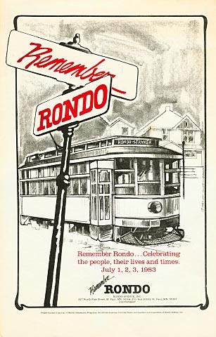
Although the African American community was injured, it maintained a strong identity. Playwright August Wilson lived in the Rondo area in the 1970s and 1980s and wrote many of his plays while living there, including several performed by the Penumbra Theatre Company. In 1983, the first annual Rondo Days Festival was held; in 2006, the Rondo Community Outreach Library opened with a mission to support community engagement.

Altshuler, Alan A. The City Planning Process: A Political Analysis. Ithaca, NY: Cornell University Press, 1965.
Credjafawn Social Club records, 1927-1971
Manuscript Collection, Minnesota Historical Society, St. Paul.
Description: Constitution, officer and member lists, minutes, reports, financial records, correspondence, announcements, and other papers relating chiefly to the social activities of this black recreational club founded in 1928. Included also are some personal papers of John R. Lawrence, a club founder and president, and some financial records of the Club's Credjafawn Credit Union.
http://www2.mnhs.org/library/findaids/P732.xml?return=q%3Dcredjafawn%2520social%2520club
Saint Paul Historical. Hallie Q. Brown Community Center.
http://saintpaulhistorical.com/items/show/260
Fairbanks, Evelyn. The Days of Rondo. St. Paul: Minnesota Historical Society Press, 1990.
Nathanson, Iric. “Linking the Twin Cities: In 1968 the Attention Was On I-94.” MinnPost, June 13, 2014.
https://www.minnpost.com/politics-policy/2014/06/linking-twin-cities-1968-attention-was-i-94
Wedin, Carolyn. “Harlem Renaissance West: Minneapolis and St. Paul, the ‘Twin Cities’ of Minnesota.” In Harlem Renaissance in the American West: The Negro’s Western Experience. Edited by Bruce A. Glasrud and Cary D. Wintz. New York: Routledge (Taylor and Francis Group), 2012.
Yuen, Laura. “Central Corridor: In the Shadow of Rondo.” MPR News, April 29, 2010.
https://www.mprnews.org/story/2010/04/20/centcorridor3-rondo
 |
 |
 |
 |
 |
 |
 |
 |
 |
 |
On June 29, 1956, the U.S. Congress passes the Federal-Aid Highway Act, which gives enormous funding for the nation’s interstate construction. After the passage of the act, construction of the I-94 corridor between St. Paul and Minneapolis begins, permanently cutting the Rondo neighborhood in half.
Joseph Rondeau purchases land in an area that eventually becomes known as the Rondo neighborhood, his namesake.
The congregation of St. Peter Claver’s Sodality moves to a building at 445 North Farrington Street, known afterward as St. Peter Claver Church.
The congregation of St. James African Methodist Episcopal (AME) Church moves into a building at 624 Central Avenue West.
The Credjafawn Social Club opens at 678 Rondo Street.
The Hallie Q. Brown Community Center opens at 553 Aurora Avenue, the former site of an African American Masonic lodge and community meeting hall.
By this year, Rondo’s more affluent residents are concentrated on the neighborhood’s west side in an area known as “Oatmeal Hill” (Upper Rondo). “Cornmeal Valley,” east of Dale Street (Lower Rondo), attracts working-class residents.
Lola Vassar (later Lola Vassar Finney) opens Finney Beauty Parlor at 437 Rondo.
Members of the Credjafawn Social Club open a cooperative grocery store (later operated as Martin’s Grocery) at 678 Rondo.
Booker T. Café and Tavern opens at 381–383 Rondo.
The Rondo–St. Anthony Improvement Association is established. The association advocates for residents whose homes and businesses are threatened by the impending highway construction.
The city planning board adopts the St. Anthony route for I-94.
St. Peter Claver Church moves to 375 Oxford Street North.
The I-94 corridor between St. Paul and Minneapolis is opened.
Rondo Days Festival, the largest African American festival in the state, is held for the first time.
The Rondo Community Outreach Library opens to the public.
Made possible by the Arts and Cultural Heritage Fund through the vote of Minnesotans on November 4, 2008. Administered by the Minnesota Historical Society.
Minnesota Historical Society • 345 W. Kellogg Blvd., St. Paul, MN 55102-1906 (Map) • 651-259-3000 © MNHS.
Send questions or comments to mnopedia![]() mnhs [dot] org. View our Privacy Policy.
mnhs [dot] org. View our Privacy Policy.