Map detailing Cleveland's proposal for a system of parkways in Minneapolis, 1883.

"Suggestions for a System of Parks and Parkways for the City of Minneapolis," June 2, 1883. Minneapolis Park and Recreation Board

Cleveland proposed a system of connected parkways to the Minneapolis Board of Park Commissioners. This map accompanied his suggestions. The parkways he proposed are shown in red. It was published as a part of the annual report of the park board in 1883.

Black and white photograph of Horace William Shaler Cleveland, date unknown.

Horace William Shaler Cleveland

Horace William Shaler Cleveland, date unknown. Uploaded by Wikimedia Commons user Minneapolis Park Board publication.

Black and white photograph of Horace William Shaler Cleveland, date unknown.

Horace William Shaler Cleveland

Horace William Shaler Cleveland, date unknown. Uploaded by Wikimedia Commons user SusanLesch.

Cleveland, Horace William Shaler (1814–1900)

Horace W. S. Cleveland was a pioneer landscape architect. His greatest achievement was designing a system of parks and parkways in Minneapolis. He advocated preserving spaces for parks in the rapidly growing cities of the American West. Cleveland was especially influential in preserving the banks of the Mississippi River gorge in St. Paul and Minneapolis as parkland.

Black and white photograph of President Lyndon Johnson, Senator Hubert Humphrey, Governor Karl Rolvaag and party at Minnehaha Falls.

President Lyndon Johnson, Senator Hubert Humphrey, Governor Karl Rolvaag and party at Minnehaha Falls.

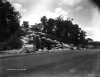
President Lyndon B. Johnson visited the falls during a campaign stop, June 27, 1964. At left is Minnesota Governor Karl Rolvaag. Behind the president is Minnesota U.S. Senator Hubert H. Humphrey, whom Johnson would choose as his vice-presidential running mate later that summer.

Black and white photograph of Godfrey Mill dam, Minnehaha Falls, c. 1889.

Godfrey Mill dam, Minnehaha Falls,

Ard Godfrey operated this mill on Minnehaha Creek below the falls before the land was acquired as a park. Photograph c.1889.

Black and white photograph of visitors below the falls, c.1869.

Two women watching Minnehaha Falls, Minneapolis.

Visitors pose on the bridge below the falls, c.1869.

Black and white photograph of Minnehaha Falls, Dakota Indians in the foreground, 1857.

Minnehaha Falls, Dakota Indians in the foreground

Dakota men pose at the falls for one of the earliest photographs taken there, 1857. Photographer: Benjamin Franklin Upton.

Minnehaha Falls, Minneapolis

The fifty-three-foot-high Minnehaha Falls was purchased by Minneapolis in 1889. It was the centerpiece of a new state park. The falls remain one of the state's most popular attractions for both residents and visitors. Their name is derived from the Dakota words mni for "water" and gaga for "falling" or "curling"—literally "water fall."

Black and white photograph of Loring Cascade, 1920.

Loring Cascade at Glenwood Park, Minneapolis.

Loring Cascade, 1920. Loring donated this artificial waterfall in 1917.

Pages

Subscribe to RSS - Cities and Towns