- Membership |
- Shop |
- Calendar |
- Donate
A resource for reliable information about significant people, places, events, and things in Minnesota history.
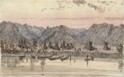
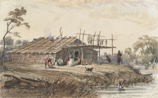
Watercolor on paper depicting Wabasha’s village of Mdewakanton Dakota on the Mississippi River, 650 miles above St. Louis. Painted ca.1845 by Seth Eastman.
The footprint of the Dakota people, past and present, is evident throughout Minnesota. Mni Sota Makoce, the land of cloudy waters, has been the homeland of the Dakota for hundreds of years. According to the Bdewakantonwan Dakota creation story, Dakota people and life began in Minnesota, and despite a tumultuous history, they continue to claim this land as their home.
It is difficult to define how Dakota people have shaped the state, when in fact the land itself has shaped the Dakota. The land—its valleys and peaks, its waterways and seasons, all the gifts it has to offer—has influenced the way Dakota have lived, interacted, sustained, and viewed themselves. And despite the environmental degradation that occurred upon European settlement, the relationship between the land and its original people continues today.
By stepping into the Dakota people’s moccasins and following the pathways they have taken across the land through history, you will better understand the original people of Minnesota. You will see how they have lived in harmony with the land, how their language has named places, and how their movements and migrations, both voluntary and forced, have been significant.
Dakota people are divided up into seven bands or council fires. All are related, share customs and practices, and are easily understood among each other. The far western bands, which use the L-dialect, Lakota, are the Titonwan (Dwellers of the Prairie). The Nakota make up the Ihanktonwan (Dwellers at the End) and Ihanktonwanna (Little Dwellers at the End). They are also located primarily west of Minnesota.
The D-dialect Dakota are considered the eastern bands, whose homelands are in Minnesota. They are sometimes called the Santee, from Isanti Mde (Knife Lake), southeast of Mille Lacs. They make up the Sisitonwan (Dwellers of the Fish Ground), Wahpetonwan (Dwellers Among the Leaves), Wahpekute (Shooters Among the Leaves), and the Bdewakantonwan (Dwellers of the Spirit Lake).
The band names are significant because they originally defined the location of each village or camp. For example, the village of the Bdewakantonwan at one time was located near Mille Lacs. Evidence of Dakota-styled burial mounds is found throughout the Mille Lacs area, typically along forests or waterways, and in places such as Shakopee Road, named after a Bdewakantonwan chief. The Ihanktonwan and Ihanktonwanna bands were named as such due to their place at the ends of the horseshoe-shaped camp where the seven bands came together.
Through our oral history and stories, we understand that the Anishinaabe (Ojibwe) who migrated through the passage of the Great Lakes pushed the Dakota further south. In fact, the history of warring between the two tribes is readily available. However, both the Dakota and Anishinaabe oral history and stories also tell of a time between the two tribes that was respectful and friendly.
The story of the Big Drum giving continues today, recognized through ceremonies. The Dakota gifted the drum to the Anishinaabe people and it has been an ongoing symbol of friendship and peace. While both tribes continue to come together in peace and often collaborate on Native issues, the government commemorated and sealed the peace between the historically warring tribes through the 1825 Treaty of Prairie du Chien, defining set boundaries of tribal land. This treaty identifies the peace boundary between the two. Today, the boundary roughly follows Interstate 94.
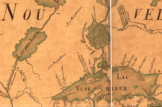
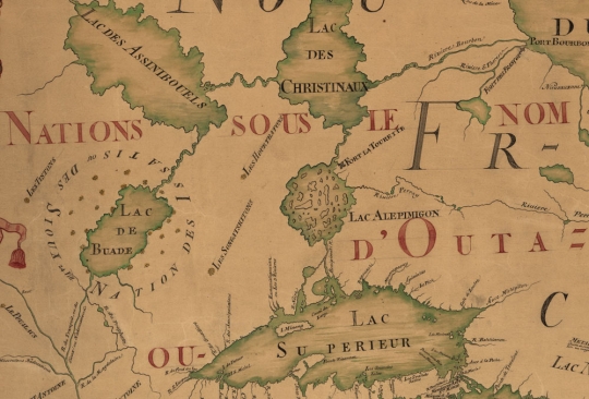
Waterways have been important to the Dakota as a means of travel, sustenance, fishing, and swimming; people have always gathered near water. Cloudy waters identifies the mighty Minnesota River and is namesake to our state. One Dakota meaning of the Minnesota River is within the place name itself, pronounced Mini–so–tah Wahk–pah: cloudy water ("cloudy" in this context could refer to misty fog, or to turbulence, or to the clear waters reflecting the sky). Different bodies of water have served multiple purposes, including the marshes, ponds, creeks, and lakes that are a source of wild rice. Year-round, springs provide access to water, and oftentimes are locations of winter camps. And birch bark and dug-out canoes traversing across lakes and up and down rivers enable trade and allow people to meet. Villages gathered around water, including the village of Chief Istahba, or Sleepy Eye, who camped near the Cottonwood River; Cloudman's village on Bde Maka Ska; and Little Crow's at Kaposia, which is in South St. Paul.
Confluences also have been important; they are where waterways of two separate origins meet together as one. They have synonymously served as gatherings sites of different peoples, but people, all the same. The confluence of the Mississippi and Minnesota Rivers at Mendota has long been significant to the Dakota people. Oral history identifies it as the origin of the Dakota people themselves and the center of the universe. Mendota, or Bdote, meaning the confluence of two rivers, has been an important site for the Dakota, French fur traders, and American soldiers, including those who built Fort Snelling, the first fort in the area, staking claim to the lands of Minnesota.
Other confluences and springs (including Wakoniya, present-day Waconia), while not quite as widely known, were also marked in earlier history by the Dakota and early French traders, pioneers and Minnesotans. Rightfully, Minnesota is known for its ten thousand lakes. While today Minnesotans utilize the waters for recreation, sport, transportation, irrigation, and industrial uses, the Dakotas’ existence was based upon the gifts the waters had to offer, and the water names identified then continue to be used today.
Primary paths in Dakota history indicate that seasons and the availability of sustenance dictated much of their movements throughout the state. Wild ricing, maple sugaring, and hunting were all reasons for moving camp and have inspired Dakota names, several of which remain as adopted locations of white settlers. These include Canhasan, a sugar camp (today Minnesotans refer to it as Chanhassen), and Kandiyohi, a place where Dakotas fished the buffalo fish and that today is a county in central Minnesota.
Additionally, areas identified as the gathering place of particular medicines or foods, including Cansasa Yankadan, a place where they gathered tobacco (red willow) and Uta Pahida (acorns). These particular Dakota place names have not been maintained by Minnesotans but are remembered through Dakota history.
Designated sites were identified in the language and the Dakota exercised conservation, which has given direction to today’s decision-making and conservation efforts. Dakota people lived in agreement with the land, its resources, and seasons. Camps were moved for that very reason, in order for the land to repair and refresh itself. Dakota people did not shape the land; they lived in harmony with nature. Today, Dakota people still understand this concept, leaving a gift, often tobacco and a prayer, when taking from the land, acknowledging that relationships, including one with the land, should be handled with reciprocity. A growing conservation movement throughout the world is widely found in Indigenous populations and is embedded within the Dakota people as well, for they end all their prayers with “Mitakuye Owasin,” all my relations.
Dakota travelled throughout Minnesota along identified paths and again, some of those names are maintained, with some variations that arose through misunderstandings of speech. For example, present-day Chokio (Cokaya) is translated as the middle or center and located along a Dakota trail. Another example is Wayzata (Waziyata), referring to the north, which references earlier migrations and travels to the northern parts of Minnesota. Other Dakota place names haven’t been maintained by white settlers. They are no longer part of Minnesota culture and language but are maintained by Dakota people. A good example is the white rock face that is exposed in St. Paul along the river, which the Dakota call Imniza skadan—small white rock. Why some Dakota names persist and others do not remains to be understood.
Early life among the Dakota, before the influx of settlers, remained fairly peaceable. The Dakota adopted fur-trade goods that made life easier. They shared the land’s resources and knowledge of its uses and locations, continuing to live according to their own set of beliefs, customs, and language. Statehood had not yet emerged, and lands to the west were viewed by many as vast and pristine. However, a period of turmoil in the 1830s can be identified first through the advent of Christian missionaries and soldiers, the westward movement, and the desire for more land for those who were immigrating from the east. One could argue that Christianity killed much of the Dakota culture even though it was the intent of the missionaries to convert and save the Dakota. Yet the language’s survival today is primarily attributed to the missionaries’ work in creating a Dakota language-writing system. Documents such as the Bible and hymn books were the impetus for creating a dictionary that is still used today: Stephen R. Riggs’s Dakota–English Dictionary.
Chief Cloud Man and his village camped at Bde Maka Ska, and this is where some of the first Dakota were exposed to the missionaries and their work. The early Presbyterian missions, including those at Lac qui Parle and Hazelwood, proposed drastic changes to the Dakota way of life. Not easily accepted, the introduction to farming contradicted much of the Dakota belief system, gender roles, and the interaction between Dakota people and the land.
As immigration and the westward movement continued, Dakota were forced into treaties, ceding most of their land in exchange for goods, services, and money. While the government fulfilled none of the treaties, the most significant and recognized are those of 1851 and 1858, both of which transferred Minnesota lands to the United States. The Dakota lost all but a ten-mile strip of land on each side of the Minnesota River, and subsequently the northern strip. The people whose way of life was dependent upon hunting, gathering, and a relationship to the land were separated. The Sisitonwan and Wahpetonwan bands were placed on the northwest end of the narrow reservation, while the Wahpekute and Bdewakantonwan bands were placed on the southeast.
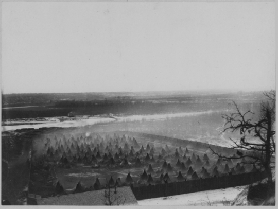
Failed treaty promises, late annuity payments, poor crops, and confinement to a narrow strip of land were the primary causes of a hostile atmosphere. The US–Dakota War of 1862 was a turning point in Dakota and state history. Unfortunately, it is a source of much of the current prejudice, misunderstanding, and lack of trust between the Dakota people and Minnesotans, the U.S. government and neighbors. A forced march in the winter of 1862, the largest mass-hanging in U.S. history, an internment camp, and, ultimately, the exile of all Dakota people from Minnesota ripped apart the very relationship between land and its people. While some Dakota fled to Canada and into present-day North Dakota before the war ended, those imprisoned in Mankato and at Fort Snelling were shipped to Davenport, Iowa; Crow Creek, South Dakota; and subsequently to Santee, Nebraska. A few Dakota, considered “friendly” during the war, remained in Minnesota and were given individual allotments.
Many Dakota remained in outlying states and Canada after the war. But during the 1880s and 1890s many Dakota people, lonesome for home, dared to come back to the land they were so inextricably tied to. Some even purchased their own land. Primary re-settlement occurred in present-day Granite Falls, Morton, Prairie Island, and Shakopee. These four Dakota communities were later federally recognized and nominal land bases were returned.
After the 1860s, while the "Indian problem” was no longer under the jurisdiction of the Department of War, the Bureau of Indian Affairs within the Department of Interior was charged with assimilating Native people. The boarding school era began in 1879 at the Carlisle Indian Industrial School, a boarding school in Carlisle, Pennsylvania. Its first director, army officer Richard Henry Pratt, coined the phrase, “kill the Indian, save the man.” The Dawes Act of 1887 and the 1956 Indian Relocation Act were both deliberate detriments to the Dakota communal and family way of life. The once-interdependent roles of and responsibilities to our tiwahe (family), tiospaye (extended family), and oyate (people and nation) within the Dakota community were forever changed.
In 1934, the Indian Reorganization Act re-established minimal land bases and defined a cookie-cutter form of government for tribal groups, including those of the Minnesota Dakota. While its legislation may have had a good intent, it was one that did not resemble the traditional ways of governing and leading. The Boarding School era, which lasted until the 1950s, removed children from their homes. Many never returned home. The Indian Relocation Act placed young adults in urban centers like Minneapolis and St. Paul for the purposes of assimilation.
The 1960s were a time of awakening for Dakota and other Native people. Their connection to their homelands and all that is related to it (kinship, history, and language) became the driving force for a period of reclamation. The American Indian Movement (AIM), originating in Minneapolis in 1968, was instrumental in this change. A desire for living in dignity was asserted, and the 1972 Indian Education Act and the 1975 Self-Determination Act were passed. Many Native Americans wondered where their children had gone, and the 1978 Indian Child Welfare Act was born. The connection to and practice of living in harmony with all living things was reclaimed, and the 1978 Indian Religious Freedom Act was born. Dakota people remembered their mother tongue, and the 1990 Native American Languages Act was born.
Within Minnesota today, the four Dakota communities exercise self-governance rights and tribal sovereignty. While many are quick to name gaming as a primary outcome of those rights, there exists much more evidence of self-determination and self-governing. This includes: tribal courts; law enforcement; health, education, and social welfare programs; and other economic initiatives. Gaming has been a primary economic engine for many of Minnesota’s tribes. Minnesota Native American gaming began in the early 1980s, and in 1988, with the passage of the Indian Gaming Regulatory Act, gaming was protected as a mechanism for economic development among Native tribes.
In 1850, 84 percent of Minnesota’s population was Native. Today it’s less than 1 percent. Take the time to learn about the first peoples of Minnesota. Mni Sota Makoce is and remains the homeland of the Dakota.

Anderson, Gary Clayton, and Alan R. Woolworth. Through Dakota Eyes: Narrative Accounts of the Minnesota Indian War of 1862. St. Paul: Minnesota Historical Society Press, 1988.
Bakeman, Mary Hawker, and Antona M. Richardson, eds. Trails of Tears: Minnesota’s Dakota Indian Exile Begins. Roseville, MN: Prairie Echoes Press, 2008.
Black Thunder, Elijah, Norma Johnson, Larry O’Connor, and Muriel Pronovost. Ehanna Woyakapi: History and Culture of the Sisseton-Wahpeton Sioux Tribe of South Dakota. Sisseton, SD: Sisseton Wahpeton Tribe, 1975.
Dahlin, Curtis A. The Dakota Uprising: A Pictorial History. Edina, MN: Beaver’s Pond Press, 2009.
Deloria, Ella. Speaking of Indians. Lincoln, NE: University of Nebraska Press, 1998.
Durand, Paul. Where the Waters Gather and the Rivers Meet. [Prior Lake, MN]: Paul C. Durand, 1994.
Eastman, Charles A. Indian Boyhood. New York: Dover Publications, 1971.
http://www.gutenberg.org/ebooks/337
Jorgensen, Miriam. Rebuilding Native Nations: Strategies For Governance and Development. Tuscon, AZ: University of Arizona Press, 2007.
Kaplan, Anne R., and Marilyn Ziebarth. Making Minnesota Territory: 1849–1858. St. Paul: Minnesota Historical Society Press, 1999.
Martinez, David. Dakota Philosopher: Charles Eastman and American Indian Thought. St. Paul: Minnesota Historical Society Press, 2009.
Meyer, Roy W. History of the Santee Sioux: United States Indian Policy on Trial. Lincoln, NE: University of Nebraska Press, 1993.
Monjeau-Marz, Corinne L. The Dakota Indian Internment at Fort Snelling, 1862–1864. St. Paul: Prairie Smoke Press, 2005.
Neuberger, Anne E. Jane Gibbs: Little Bird That Was Caught. St. Paul: Ramsey County Historical Society, 1998.
Pond, Samuel W. Dakota Life in the Upper Midwest. St. Paul: Minnesota Historical Society Press, 1986.
Riggs, Stephen Return. Dakota–English Dictionary. Minneapolis: Ross & Haines, 1968.
Roberts, Kate. Minnesota 150: The People, Places, and Things That Shape Our State. St. Paul: Minnesota Historical Society Press, 2007.
Roper, Eric. "What does 'Minnesota' Mean and How Did the State Get Its Name?" Minneapolis Star Tribune, December 17, 2021.
https://www.startribune.com/mnisota-mni-sota-dakota-language-minnesota-river-state-name/600114154
Spector, Janet D. What This Awl Means: Feminist Archaeology at a Wahpeton Dakota Village. St. Paul: Minnesota Historical Society Press, 1993.
Standing Rock Sioux Tribe. Treaties and Agreements and the Proceedings of the Treaties and Agreements of the Tribes and Bands of the Sioux Nation. [South Dakota]: Standing Rock Sioux Tribe, 1973.
Swain, Gwenyth. Little Crow, Taoyateduta, Leader of the Dakota. St. Paul: Minnesota Historical Society Press, 2004.
University of Minnesota–Morris Board of Regents. Promise of the Prairie: Education in Three Acts. Morris, MN: University of Minnesota at Morris, 2010.
Wakefield, Sarah F. Six Weeks in Sioux Tepees: A Narrative of Indian Captivity. Norman, OK: University of Oklahoma Press, 2002.
Westerman, Gwen, and Bruce White. Mni Sota Makoce: The Land of the Dakota. St. Paul: Minnesota Historical Society Press, 2012.
Williamson, John P. An English–Dakota Dictionary: Wasicun Ka Dakota Ieska Wowapi. Minneapolis: Ross and Haines, 1970.
 |
 |
 |
 |
 |
 |
 |
 |
 |
 |
 |
 |
 |
 |
 |
 |
 |
 |
 |
 |
 |
 |
The underlying question, “How have the Dakota shaped the state?” is difficult to answer until we invert it: “How has the land shaped the Dakota?” This speaks of the difference in philosophy between the Dakota and mainstream views.
Minnesota. The state name itself is extracted from its original inhabitants and the Dakota language. Minisota, cloudy waters, refers to the Minnesota River, originating in and snaking its way through the state.
Dakota language. The mother tongue of the Dakota is evident in the state’s place names, including cities, counties, waterways, and significant sites.
Pre-contact. Dakota kinship, its society based on the seven council fires (the Great Sioux Nation), a relationship to land, water, seasons, and life, and living in harmony with land and nature indemnify the Dakota way of life.
Waterways. Of significant importance to Dakotas are the many waterways throughout the land that can be identified by place names, locations of villages and camps, and histories.
The change. Missionaries, settlers, and soldiers, and the way of life they imposed, clashed with and greatly changed the Dakota way of life.
The great loss. Dakota people and their relationship to the land and waters were negatively impacted through treaty-making, the U.S.–Dakota War of 1862, and, ultimately, exile from their homelands.
Returning home. While Dakota remained exiled after the war, many families returned to their homelands. This is evidenced today in the four Dakota communities and other pockets of Dakota people throughout the state.
Assimilation. Several federal Indian policies negatively affected the Dakota kinship system, culture, and language.
Reorganizing and reclaiming. Grassroots efforts and movements, with some government-supported initiatives, aimed to re-establish Dakota communities, dignity, and self-determination.
Today. Dakota are still here. A geographically separated and fragmented Dakota (Sioux) Nation consists of four federally recognized Minnesota Dakota communities and several Dakota communities and reservations in outlying states and Canada.
Dakota people live in areas southwest of Mille Lacs and on the banks of the Minnesota River.
Dakota enjoy a period of peace with their Anishinaabe (Ojibwe) neighbors in the Minnesota region. Marriages are made between the two tribes.
Dakota begin to trade with the French at a post on Lake Pepin.
Conflicts arise as Anishinaabe groups move east and north into areas traditionally occupied by Dakota.
The Dakota leaders Cetan Wakuwa Mani (Hawk that Hunts While Walking, also called Little Crow; the grandfather of the later war leader) and Wanyaga Inazin (He Sees Standing Up, also called Penichon) sign a treaty with the United States.
The first Treaty of Prairie du Chien establishes a territory for the Dakota that includes parts of present-day Minnesota, Wisconsin, Iowa, South Dakota, and North Dakota.
Treaties signed at Mendota and Traverse de Sioux reduce Dakota lands to a ten-mile piece of territory on either side of the Minnesota River.
The U.S. government forces the Dakota to cede their lands north of the Minnesota River.
The U.S. government repeatedly fails to provide food, supplies, and money promised to the Dakota in multiple treaties.
The U.S.–Dakota War begins in August and ends in September with the formal expulsion of Dakota people from Minnesota.
Some Dakota return to Minnesota, forming the beginnings of present-day communities in Granite Falls, Morton, Prairie Island, and Shakopee.
The U.S. Congress passes the Indian Reorganization Act.
The American Indian Movement (AIM) forms in Minneapolis.
Minnesota Dakota communities carry out grassroots initiatives that provide social services, preserve the Dakota language, and educate young people about traditional Dakota culture.
Made possible by the Arts and Cultural Heritage Fund through the vote of Minnesotans on November 4, 2008. Administered by the Minnesota Historical Society.
Minnesota Historical Society • 345 W. Kellogg Blvd., St. Paul, MN 55102-1906 (Map) • 651-259-3000 © MNHS.
Send questions or comments to mnopedia![]() mnhs [dot] org. View our Privacy Policy.
mnhs [dot] org. View our Privacy Policy.