- Membership |
- Shop |
- Calendar |
- Donate
A resource for reliable information about significant people, places, events, and things in Minnesota history.
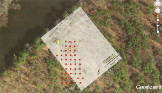
Google map of the Cadotte Post site with overlay of Douglas Birk’s 1972 sketch and an approximation of the location of the survey grid. From, Hayes, Katherine. Results of Survey and Excavation of the Little Round Hill (2WD16) and Cadotte Post (21WD17) Sites in Wadena County, Minnesota: A View of the Fur Trade in the Late Eighteenth Century. Report prepared for the Wadena County Historical Society, 2014.
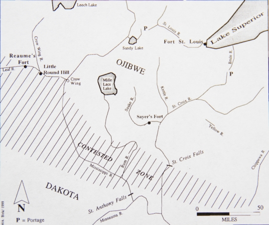
The Cadotte Post was a fur trade encampment in the late eighteenth century—one of three archaeological sites in Wadena County identified through Ojibwe oral tradition as a late-1700s trading fort. It stood just north of the Crow Wing River on its east bank, south and opposite the mouth of the Leaf River in what later became the Old Wadena County Park.
In 1790, Jean-Baptiste Cadotte and others set out to winter on the Crow Wing River near hunting grounds claimed by both the Ojibwe and the Dakota. Cadotte was of mixed French and Ojibwe heritage and noted for his courage and fearlessness. He formed a party of sixty people consisting of traders and a few Iroquois who had assumed the habits and performed the labor of northern Great Lakes voyageurs.
The party also included another independent trader, Jean-Baptiste Réaume, and his own men. After all were fully equipped for trading and trapping, they set out together late in 1791 to look for a site to build a winter encampment. As they traveled, the group discovered many signs of beaver along the Crow Wing River. They also discovered signs of the Dakota, on whose hunting grounds they were encroaching.
As they proceeded up the Crow Wing River and cold weather set in, the party set up camp opposite the mouth of the Leaf River. They then built a substantial set of buildings, including log cabins, with fortifications. Cadotte ordered men to build a log fence around his cabin for defense against possible attack.
The post was used as a base for hunting, trading, and diplomatic excursions. When a party of Dakota attacked the post to defend their hunting grounds, Cadotte gave them tobacco and ammunition as a sign of goodwill, and the two groups negotiated a truce. In spring, once the river was clear of ice, the group proceeded up the Leaf River to a portage that connected to the Otter Tail and then the Red River of the North, making a long circle that eventually brought them back to their starting point.
Between 1848 and 1849, historian William Warren collected oral histories from Ojibwe elders that were eventually published in his History of the Ojibway People. One of them provided information about Cadotte’s post, including its buildings, the traders who lived there, and their interactions with nearby Dakota.
By 1902, the area where the Cadotte Post had stood had become part of the timber lands owned by Potlatch Corporation. After it was logged over, it was acquired by the Wadena County and incorporated into its parks system.
In 1972, archaeologist Douglas Birk visited the site. He documented the remnant signs of a military road, first used in the 1840s, that connected Fort Ripley with the Crow Wing area. He also noted a river landing cut into the steep river bank. At the site of the Cadotte winter encampment, he recorded several excellently preserved cellar depressions at the head of the landing and across the old road.
Birk also noted surface finds, including lithic and ceramic materials, faunal remains, nail fragments, glass bottle shards, and one white glass seed bead. Later, he learned that individuals using metal detectors had already combed the grounds and collected knife blades, a rifle barrel, an awl point, a pair of scissors, nails, and an axe blade, among other items.
Between 2009 and 2010, Dr. Katherine Hayes of the University of Minnesota led an excavation of the site of Cadotte's post. At that time, two of the cellar depressions noted by Birk were still reasonably intact while a third had suffered extensive damage from logging activity. Several other depressions noted from Birk's visit were no longer identifiable.
To be certain, the team conducted shovel-test pits of the site. All thirty-six units indicated that logging removals had stripped all of the upper developed soils. All that was left was the sandy sterile subsoil. The test pits were thoroughly screened but very little was recovered. Nothing was left at the site that indicated a date of occupation. Because of this, no further excavations were conducted.
In 2017, all that remains of the Cadotte Post are Ojibwe oral histories and the details recorded in Warren’s History of the Ojibwe People.

Allard, Amélie. “Communities on the Move: Practice and Mobility in the late Eighteenth-Century Western Great Lakes Fur Trade.” PhD diss., University of Minnesota, 2016.
Birk, Douglas A. “A Preliminary Archaeological Study of the Little Round Hill Site, Old Wadena Park, Wadena County, Minnesota.” Reports of Investigation no. 214. Institute for Minnesota Archaeology, 1992.
Hayes, Katherine. Results of Survey and Excavation of the Little Round Hill (2WD16) and Cadotte Post (21WD17) Sites in Wadena County, Minnesota: A View of the Fur Trade in the Late Eighteenth Century. Report prepared for the Wadena County Historical Society, 2016.
Warren, William W. History of the Ojibway People. St. Paul: Minnesota Historical Society Press, 1885. Reprinted 1984.
 |
 |
As cold weather arrives in late 1791, Jean-Baptiste Cadotte and a trading party build a trading post on the east bank of the Crow Wing River, close to its intersection with the Leaf River.
French fur trader Jean-Baptiste Cadotte camps for the winter on the east bank of the Crow Wing River opposite the mouth of the Leaf River.
Ojibwe historian William Warren collects oral histories about Cadotte’s post.
The Potlatch Corporation is established and begins logging in central Minnesota.
Wadena County acquires the property for development as a park.
A relic hunter using a metal detector removes several artifacts from the site, including knife blades, an awl point, scissors, and nails.
Archaeologist Douglas Birk visits the site to survey it for the state historical society as a potential National Register property in the Mississippi Headwaters Region.
The "Old Wadena Historic District" is listed on the National Register of Historic Places for its relevance to the history of agriculture, non-aboriginal archaeology, and transportation.
The Institute for Minnesota Archaeology conducts a preliminary survey and assessment of the nearby Little Round Hill or “blacksmith” site at Old Wadena County Park.
A team led by University of Minnesota professor Dr. Katherine Hayes survey tests the site of Cadotte's post. Results indicate that further excavation is not warranted.
Made possible by the Arts and Cultural Heritage Fund through the vote of Minnesotans on November 4, 2008. Administered by the Minnesota Historical Society.
Minnesota Historical Society • 345 W. Kellogg Blvd., St. Paul, MN 55102-1906 (Map) • 651-259-3000 © MNHS.
Send questions or comments to mnopedia![]() mnhs [dot] org. View our Privacy Policy.
mnhs [dot] org. View our Privacy Policy.