- Membership |
- Shop |
- Calendar |
- Donate
A resource for reliable information about significant people, places, events, and things in Minnesota history.
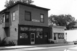
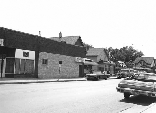
U-Meet-Us, Black Senior Citizens Lounge, and Minneapolis Urban League, East 38th St and 4th Ave, Minneapolis, 1975.
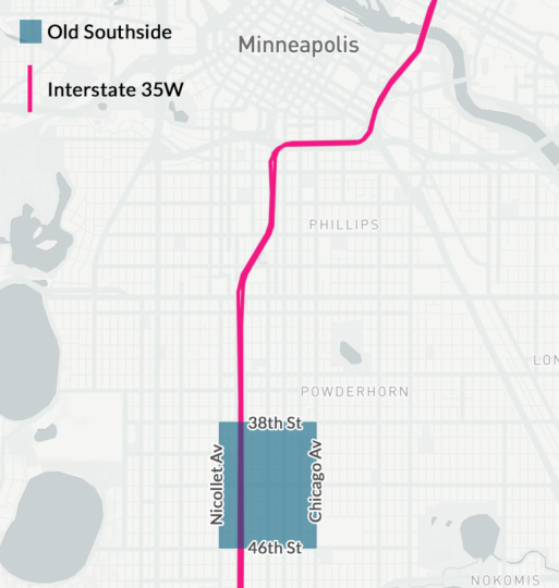
Minneapolis historically has been home to a small but vibrant African American population. From the 1930s to the 1970s, an African American neighborhood flourished on the city’s Southside, between East Thirty-Fourth and Forty-Sixth Streets and from Nicollet Avenue to Chicago Avenue.
In the early twentieth century, restrictive housing covenants in deeds discriminated against Black people and limited them to living in certain areas. Homeowners and realtors refused to sell houses to them in white neighborhoods. As a result, three distinct Black neighborhoods developed in Minneapolis. The first two emerged on the near Northside and in Seven Corners.
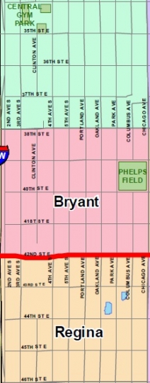
By the 1930s, African Americans had begun to move to South Minneapolis. They came along with an influx of Black people from southern states who were moving north in a demographic shift known as the “Great Migration.” The city’s third Black neighborhood developed on the Southside, between East Thirty-Fourth and Forty-Sixth Streets and from Nicollet Avenue to Chicago Avenue. The area, first populated by Swedes and Norwegians, now attracted many African Americans. In the 2010s, the Central, Bryant, and Regina neighborhoods make up what was historically known as the Southside.
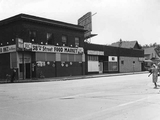
The Southside was a stable neighborhood of working and middle-class African Americans, many of whom owned their homes. Residents formed a tight-knit community with businesses, churches, and social clubs. The corridor along Fourth Avenue South was the Black community’s residential heart. Thirty-Eighth Street and Fourth Avenue was the center of the Black business district, with over twenty Black-owned businesses from the 1930s to the 1970s.
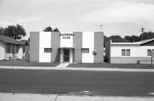
One of the neighborhood’s first businesses was Dreamland Café, which opened in 1939 and was owned by Anthony B. Cassius. Later, Cassius operated a private club on the Southside called the Nacirema (“American” spelled backwards). Local artists performed at the Nacirema before they became famous, including Prince, Flyte Tyme (The Time), and Alexander O’Neal.
Alvedia Smith, the daughter of Anthony and Florence Cassius, said the Southside was a nice neighborhood. Smith worked at Dreamland Café when she was a teenager, making sandwiches for customers. Her aunt owned Bea’s Beauty Shop, her father and uncle owned a real estate company, and her father was chairman of the Associated Negro Credit Union, which was established in 1937.
Another pioneer Southside business was the 38th Street Delicatessen, owned by Donald (Pat) and Pearl Schofield. Sandra Schofield Miller said her father opened a bakery specializing in wedding cakes before closing it and opening the delicatessen in the 1940s.
Miller and her sister, Marcia Schofield Dudley, worked at the restaurant, which was a community meeting place. Men stopped by for coffee in the mornings, and in the afternoons, students from Bryant Junior High ate the “blue plate special” lunch. Miller said out-of-town Black entertainers dined at the restaurant when they stayed with Black families on the Southside because they could not stay at white hotels downtown. Miller recalled that Frankie Lymon ate at the restaurant and kissed the back of her hand.
The Minnesota Spokesman-Recorder (formerly the Minneapolis Spokesman and the St. Paul Recorder), the oldest continuously operated Black newspaper in Minnesota, was founded in 1934 by Cecil Newman. In 1958 it moved to 3744 Fourth Avenue South. In 2015, the Spokesman-Recorder building celebrated its eightieth anniversary and was designated a historic landmark.
Construction of I-35W in 1959 razed more than fifty square blocks and divided Southside residents from one another. The neighborhood changed further in the 1980s and the 2000s, when it was negatively impacted by rising crime, harsh economic conditions, and the crack cocaine epidemic. The closing of the last local school, Central High School, in 1982, destroyed the neighborhood’s cohesiveness. All of the African American businesses closed except the Spokesman-Recorder. The demographics of the Central and Bryant neighborhoods changed as the white and Black populations decreased. The Hispanic population also increased, surpassing both the Black and white populations.
In 2015, community members expressed interest in preserving the African American history in the neighborhood. The City of Minneapolis explored a historic designation for the Tilsenbilt Homes, a group of over fifty houses in the Bryant and Regina neighborhoods. They were built from 1954 to 1956 by Edward Tilsen and sold to Blacks with the assistance of Archie Givens and the Minneapolis Urban League. Another historic landmark in the neighborhood is the home of Lena O. Smith, who was the first female African American attorney in Minneapolis.

City of Minneapolis. The Future of East 38th Street: A 2015 Community Meeting Series Starting February 4.
Originally found at: http://www.minneapolismn.gov/ward8/WCMSP-172208
——— . Tilsenbilt Homes Potential Historic District.
Originally found at: http://www.minneapolismn.gov/hpc/tilsenbilt
——— . 2000 Race and Ethnicity by Neighborhood.
http://www.ci.minneapolis.mn.us/census/2000/census_2000-race-and-ethnicity-by-neighborhood
Metropolitan Population Study. Twin Cities Metropolitan Planning Commission, March 1962.
Miller, Schofield Sandra. Interview with the author, November 15, 2016.
Mindrum, Beverly. “The Negro: Bias in our Backyard?” Minneapolis Star, October 28, 1963.
Minority Population Trends in the Twin Cities Metropolitan Area, 1980. St. Paul: Metropolitan Council, 1983.
Minneapolis City Directory. St. Paul: R. L. Polk & Co., 1937, 1966, 1967.
Minnesota Compass, Central Neighborhood, Bryant Neighborhood and Regina Neighborhood, 2010–2014.
http://www.mncompass.org/profiles/neighborhoods/minneapolis
Pike, Denise. "Old Southside Minneapolis and the 35W Dividing Line." A Public History of 35W, April 29, 2020.
Originally at: https://35w.heritage.dash.umn.edu/essays/old-southside-minneapolis-and-the-35w-dividing-line/
Population Profile of the Twin Cities Metropolitan Area, Development Framework Data Report. Metropolitan Council of the Twin Cities Area, May 1974.
Shirk, Ronald W. Minneapolis Population and Racial Change, 1950 –1990, with 1980 and 1990 Census Tract Information. Minneapolis: Office of the City Coordinator, City Planning Department, 1991.
Smith, Alvedia. Interview with the author, November 11, 2016.
United States Census of Population, 1930. Geographic Distribution and Increase Negroes in the United States, Table 12 – Negro and White Populations, By Sections, Divisions, and States: 1790 to 1930.
United States Census of Population, 1930. Composition and Characteristics, Table 23 – Population by Sex, Color, Age, Etc., for Cities of 50,000 or More by Wards: 1930.
United States Census of Population, 1930. Occupations, Table 12 – Number of Negroes Engaged in Principal Professions, by Sections and Divisions, and States: 1930.
United States Census of Population, 1940. Statistics for Census Tracts, Table 3a – Nonwhite Population by Years of School Completed, Employment Status, Class of Worker, and Sex by Census Tracts: 1940.
United States Census of Population, 1940. Statistics for Census Tracts, Table 4 – Dwelling Units by Occupancy Status and Race of Occupants, by Census Tracts: 1940.
United States Census of Population, 1940. Characteristics of the Population, Table 34 – Race and Age, by Sex, for Cities of 50,000 or More by Wards: 1940.
United States Census of Population, 1950. Minnesota, Table 34 – General Characteristics of the Population, for Standard Metropolitan Areas, Urbanized Areas, and Urban Places of 10,000 or More: 1950.
United States Census of Population, 1950. Minnesota, Table 83 – Race and Class of Worker of Employed Persons, by Industry and Sex, for the State and for Standard Metropolitan Areas of 100,000 or more: 1950.
United States Census of Population, 1960. Minnesota, Table 21 – Characteristics of the Population, for Standard Metropolitan Statistical Areas, Urbanized Areas, and Urban Places of 10,000 or more: 1960.
United States Census of Population, 1970. Table 24 – Age by Race and Sex, for Areas and Places: 1970.
 |
 |
 |
 |
 |
 |
 |
 |
 |
 |
 |
 |
Between 1950 and 1960, the Black population in the Southside neighborhood increases by 285%—from 1,209 to 3,447.
St. Peter’s AME (African Methodist Episcopal) Church is founded. (It moved to 401 East Forty-First Street in 1952.)
St. Thomas Episcopal Church is founded at 4400 Fourth Avenue South (it closed in 2008).
The total Minneapolis population is 464,356; the city’s Black population is 4,176.
The Associated Negro Credit Union opens for business at 3744 Fourth Avenue South.
The total Minneapolis population is 492,370, and the Black population is 4,646. The 1940 Census shows that the Southside’s total population is 10,428 and the black population is 712, or 15 percent.
The total Minneapolis population is 521,718, and the Black population is 6,807.
The city’s Black population increases significantly, growing to 11,785. The total population in Minneapolis falls to 482,872.
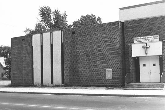
Sabathani Baptist Church forms a congregation in a building at 3802 Third Avenue South.
Warrington Elementary School, at the corner of Thirty-Seventh Street and Third Avenue, closes.
Members of the Sabathani Baptist Church open the Sabathani Community Center.
The Black population continues to increase, to 19,005 compared to the total population in Minneapolis of 434,400.
Bryant Junior High School (310 East Thirty-Eighth Street) closes.
Sabathani Community Center moves into the vacant Bryant Junior High School building.
Central High School (3416 Fourth Avenue) closes.
The census reported a large concentration of Black residents in the Central and Bryant neighborhoods with the black population in both these neighborhoods greater than 50 percent.
The Black and white populations in the Central and Bryant neighborhoods begin to decrease, and Latinx people move into the area.
Made possible by the Arts and Cultural Heritage Fund through the vote of Minnesotans on November 4, 2008. Administered by the Minnesota Historical Society.
Minnesota Historical Society • 345 W. Kellogg Blvd., St. Paul, MN 55102-1906 (Map) • 651-259-3000 © MNHS.
Send questions or comments to mnopedia![]() mnhs [dot] org. View our Privacy Policy.
mnhs [dot] org. View our Privacy Policy.
 Facebook
 Twitter