- Membership |
- Shop |
- Calendar |
- Donate
A resource for reliable information about significant people, places, events, and things in Minnesota history.

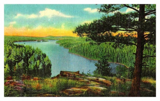
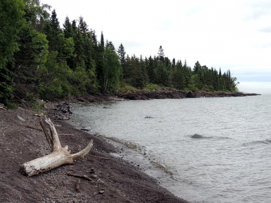
Bird’s-eye view of the Superior National Forest. Photograph by Flickr user Phil, September 23, 2013. CC BY-SA 2.0
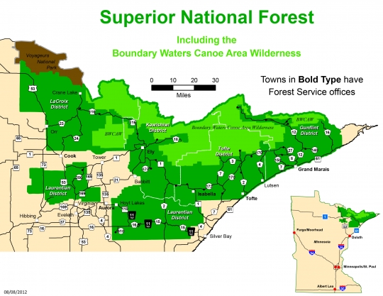
Superior National Forest is an iconic part of northeast Minnesota that comprises over three million acres (more than 445,000 of which are surface water) of boreal forest. The forest itself is part of the vast North Woods, a tourist destination in northern Wisconsin and Minnesota and the Upper Peninsula of Michigan. The Boundary Waters Canoe Area Wilderness (BWCA) is within the forest, which is itself part of the Quetico Superior region that extends into Canada.
The topography of the Superior National Forest was carved about 30,000 years ago during the Wisconsinan Glacial Period by the Laurentide Ice Sheet. After thousands of years of glacial expansion and retraction, the ice sheet retreated northward, leaving behind lowland areas that flooded and became many of the lakes in the North Woods.
People have lived in the North Woods forest for more than 10,000 years. By the mid-seventeenth century the Dakota, Cree, and Assiniboine lived there, and the migrating Ojibwe established themselves on western Lake Superior by the 1680s. All of them harvested wild rice, used fire to increase agricultural yields of plants such as blueberries, and maintained ecological borderlands (ecotones) to support elk, moose, and deer populations. The French fur trade arrived in 1679 with Sieur du Lhut, and the Ojibwe and the French traded on the shores of Lake Superior throughout the eighteenth century.
In the 1850s, the US government, settler-colonists, and logging companies were eager to exploit the North Woods’ timber and mineral resources. Under ecological and economic pressure, due to the wane of the fur trade, the Ojibwe ceded most of what is now the Superior National Forest in 1854 in the Treaty of La Pointe and were promised by the US government annuities, reservations, and retained land-use rights. (Intensive lumbering later eroded their freedom to use the ceded territory through the twentieth century, but the Ojibwe reasserted their treaty rights in the 1980s and 1990s; subsequent court cases upheld their right to hunt, fish, and harvest on ceded land.)
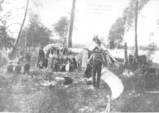
During and after the treaty era, deposits of iron ore and myths of gold drew miners and capitalists to the North Woods. Miners and their families founded or expanded settlements, such as Ely, while commercial logging began in earnest in the 1890s. Tourism was advertised for the National Forest as early as 1915, and in 1919 as a primeval wilderness perfect for “the camper, the fisherman, and the canoeist.”
As European forestry conservation practices—setting aside tracts of land for future use, suppressing fire, and wilderness tourism—gained ground in the late nineteenth century and early twentieth, large tracts of the North Woods became cut-over wasteland. Some conservationists proposed setting aside forested land. Minnesota’s chief fire warden Christopher C. Andrews, for example, suggested the idea in 1891. Meanwhile, wildlife enthusiasts (like the Canadian W. A. Preston, who was concerned about the looming demise of the moose from poaching) called for the creation of an international reserve.
Through shared concern and cross-border communication, three things happened in rapid succession in 1909. First, the state of Minnesota established the Superior Refuge in the northeast for moose and caribou (but allowed for the hunting of wolves and beavers). Second, Theodore Roosevelt declared 644,114 acres the Superior National Forest on February 13. Third, Canada established the Quetico Forest Reserve (Quetico Provincial Park), the Superior Forest’s twin, on April 1. Presidents William H. Taft (1912), Calvin Coolidge (1927), Franklin D. Roosevelt (1936), and John F. Kennedy (1962) further expanded the Superior National Forest.
Throughout the twentieth century, environmental activists fought to preserve wilderness within the forest—though not all of it. In 1926, Secretary of Agriculture William Jardine signed off on the establishment of the Superior Roadless Area to provide outdoor wilderness recreation. In 1931, the Shipstead-Nolan Act protected federal shorelines from logging and flooding—inhibiting any future dam plans. Likewise, although only around 40 percent of land within the forest’s boundaries was publicly owned by the 1920s, as cutover property was abandoned in the 1930s and 1940s, the national forest added 60 percent of formerly privately-owned land to public ownership.
Infrastructure projects completed by the Civilian Conservation Corps (CCC) in the 1930s facilitated logging inside the forest, as did trucks, chainsaws, and dozers. In 1949, Truman’s Executive Order of an Air Space Reservation over the Roadless Area curtailed air traffic, effectively ending the use of sea planes by resorts in the Roadless Area. Later, the 1964 Wilderness Act created a federal wilderness system and the BWCA, while President Jimmy Carter’s 1978 Public Law 95-495 (BWCA Wilderness Act) permanently ended logging within the Boundary Waters, though not in the rest of the forest.

Forester, Jeff. The Forest for the Trees: How Humans Shaped the North Woods. St. Paul: Minnesota Historical Society Press, 2004.
Johnson, Benjamin Heber. “Conservation, Subsistence, and Class at the Birth of Superior National Forest.” Environmental History 4, no. 1 (1999): 80–99.
https://www.jstor.org/stable/3985329
Marcotty, Josephine. “Saving the Great North Woods.” Minneapolis Star Tribune, October 17, 2013.
https://www.startribune.com/star-tribune-special-report-saving-the-great-north-woods/228250501
Mickelson, David M., and John W. Attig. “Laurentide Ice Sheet: Ice-Margin Positions in Wisconsin.” Wisconsin Geological and Natural History Survey, 2017.
https://wgnhs.wisc.edu/catalog/dataset/000939/resource/es056?view_id=a9c5754f-3aae-46a4-ac91-3f6635d4e862
Miller, Char. “Book Excerpt: America’s Great National Forests, Wildernesses, and Grasslands.” Save the Boundary Waters, August 3, 2016.
https://www.savetheboundarywaters.org/updates/book-excerpt-americas-great-national-forests-wildernesses-and-grasslands
Minnesota Department of Natural Resources. “Legal History.”
https://www.dnr.state.mn.us/aboutdnr/laws_treaties/1854/litigation.html
Minnesota Geological Survey, University of Minnesota. “Glacial Geology.”
https://cse.umn.edu/mgs/glacial-geology
Minnesota Geological Survey, University of Minnesota. “Minnesota at a Glance: Precambrian Geology,” revised 2020.
https://conservancy.umn.edu/bitstream/handle/11299/59424/mn%20glance%20precambrian%202%20page.pdf
US–Dakota War. Minnesota Historical Society. “Minnesota Treaty Interactive.”
https://www.usdakotawar.org/history/treaties/minnesota-treaty-interactive
Morey, G. B., and Henk Dahlberg. Geology of Minnesota: A Guide for Teachers. Minnesota Department of Natural Resources, 1995.
https://files.dnr.state.mn.us/lands_minerals/geologyhandbook.pdf
Myers, John. “Nature Conservancy Buys 2,110 Acres in Heart of Superior National Forest." MPR News, October 7, 2020.
https://www.mprnews.org/story/2020/10/07/nature-conservancy-buys-2110-acres-in-heart-of-superior-national-forest
Olson, Sigurd F. “Voyageur’s Country: The Story of the Quetico-Superior Country.” Wilson Bulletin 65, no. 1 (1953): 56–59.
https://www.jstor.org/stable/4158177
Searle, R. Newell. “Autoes or Canoes? Wilderness Controversy in the Superior National Forest.” Journal of Forest History 22, no. 2 (1978): 68–77.
https://www.jstor.org/stable/3983329
Steinson, Elizabeth. “Ojibwe Absent Narratives in Minnesota Forest Park History.” Master’s thesis, St. Cloud State University, 2018.
https://repository.stcloudstate.edu/cgi/viewcontent.cgi?article=1018&context=hist_etds
Superior National Forest Headquarters. Heritage: Centennial Edition. USDA Forest Service, 2009.
https://www.fs.usda.gov/Internet/FSE_DOCUMENTS/stelprdb5367555.pdf
Thompson, Douglas P. "The Right to Hunt and Fish Therein: Understanding Chippewa Treaty Rights in Minnesota’s 1854 Ceded Treaty." 1854 Treaty Authority, updated 2020.
https://www.1854treatyauthority.org/images/ToHuntandFish.updated2020.pdf
United States Department of Agriculture Forest Service. A Vacation Land of Lakes and Woods:
The Superior National Forest. Washington, DC: Government Printing Office, 1919.
https://catalog.hathitrust.org/Record/002011218
United States Department of Agriculture Forest Service. “About the Forest.”
https://www.fs.usda.gov/main/superior/about-forest
United States Department of Agriculture Forest Service. “Historic Contact.”
https://www.fs.usda.gov/detail/superior/learning/history-culture/?cid=fsm91_049856
United States Department of Agriculture Forest Service. “Post Contact.”
https://www.fs.usda.gov/detail/superior/learning/history-culture/?cid=fsm91_049843
White, Wes. “Evolution of the Superior National Forest.” USDA Forest Service.
https://www.fs.usda.gov/Internet/FSE_DOCUMENTS/fseprd532398.pdf
 |
 |
 |
 |
 |
 |
 |
 |
 |
 |
 |
 |
Logging in Minnesota's North Woods accelerates in the 1890s, prompting naturalists, wildlife enthusiasts, and other advocates to lobby for its conservation.
The bedrock of the present-day Superior National Forest forms during the Precambrian Era.
The Laurentide Ice Sheet covers much of the region that will become the Superior National Forest.
Indigenous peoples occupy and steward the North Woods region.
French travelers arrive, initiating the fur trade in the area.
Great Britain officially claims jurisdiction over the northern forests of North America with the Treaty of Paris after the Seven Years’ War.
The United States claims the region from the British as part of the Peace of Paris, though British fur companies continue to operate there.
The Ojibwe sign treaties that transfer most of the land of the region to the United States.
Rich iron deposits and rumors of gold draw American and European miners to the region. Logging also begins.
Logging in the forest escalates.
Superior National Forest is established to conserve timber, although much of its initial footprint is cut-over land. Quetico Forest Reserve (later Quetico Provincial Park) is established on the other side of the border.
Forest Service workers build the first fire tower in the Superior National Forest designed to locate and suppress forest fires.
US Secretary of Agriculture William Marian Jardine creates the Superior Roadless Area, a precursor to the Boundary Waters Canoe Area Wilderness.
The US government buys private cut-over lands within the Forest’s borders by the government. It deploys the Civilian Conservation Corps to create modern infrastructure such as roads and trails.
The Wilderness Act creates the Boundary Waters Canoe Area Wilderness, (BWCAW), whose character is affirmed and expanded by the 1978 BWCAW Wilderness Act.
The Grand Portage and Bois Forte Bands of Chippewa (Ojibwe) reassert their off-reservation hunting, fishing, and gathering rights via a lawsuit, culminating in an agreement between the Ojibwe and the state of Minnesota in 1988.
The Nature Conservancy purchases over 2,000 privately held acres in the forest to keep them undeveloped.