A resource for reliable information about significant people, places, events, and things in Minnesota history.

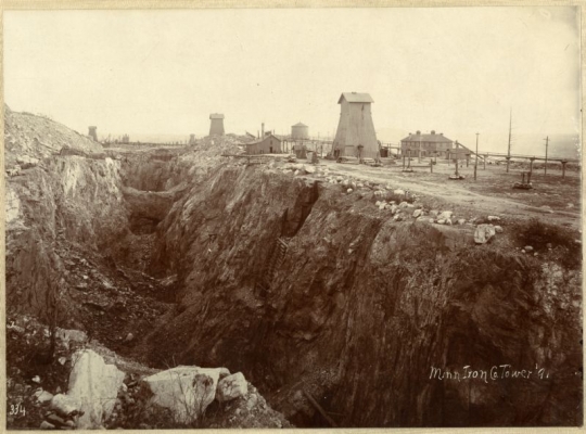
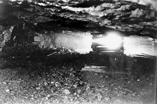
A mine in the Vermilion Iron Range operated by the Minnesota Iron Company, 1891. Photograph by Crandal & Fletcher Studio, Duluth.
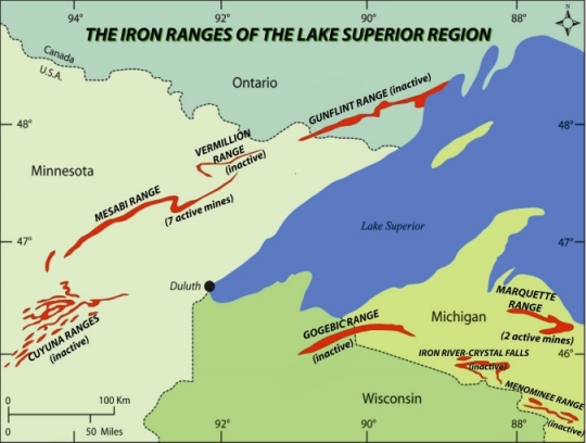
The Vermilion Range, with its distinctive hard and high-grade iron ore deposits, looms large in the history of the mining industry in Minnesota. It was the first range to open (1884) and also the first to cease commercial mining operations (1967) due to changes in the steel-making process and the rise of cheaper-to-produce taconite on the nearby Mesabi Range. After mining ended, the area’s protected wilderness spaces—including the Boundary Waters Canoe Area Wilderness—took center stage in a new regional economy based on tourism and conservation.
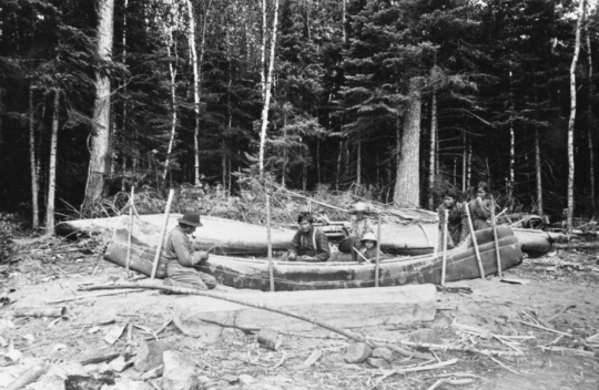
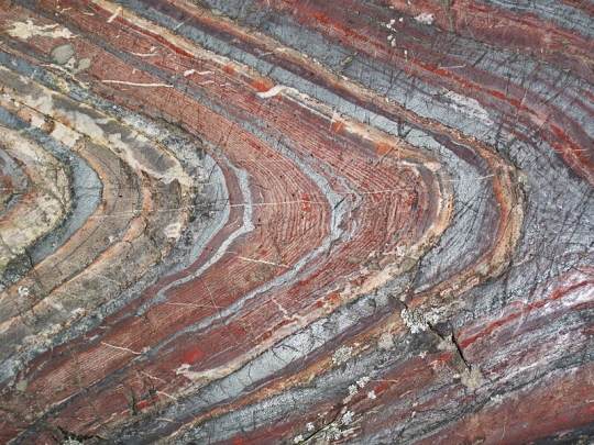
Millions of years ago, the land known as the Vermilion Range (between the present-day cities of Tower and Ely) was covered by an inland sea. Volcanic rock decomposition produced rich iron deposits of inter-bedded chert, magnetite, and hematite that later defined the region. By the mid-1700s, Ojibwe people lived there, especially around Onamuni Zaaga’iganiin (the lake with the sunset glow, later also called Lake Vermilion). When French traders arrived, they called the surrounding forests Bois Forte (Big Woods) after the local Ojibwe, who called themselves Zagaakwaandagowininiwag (men of the thick-fir woods).
The Bois Forte Ojibwe knew about the minerals in their homeland and shared that knowledge with the Europeans who visited during the fur trade era (ca. 1679–1854). In 1849, Minnesota’s territorial governor, Alexander Ramsey, called for a road to be built from St. Paul to Lake Superior to open up northeast Minnesota’s rich mineral lands to trade.
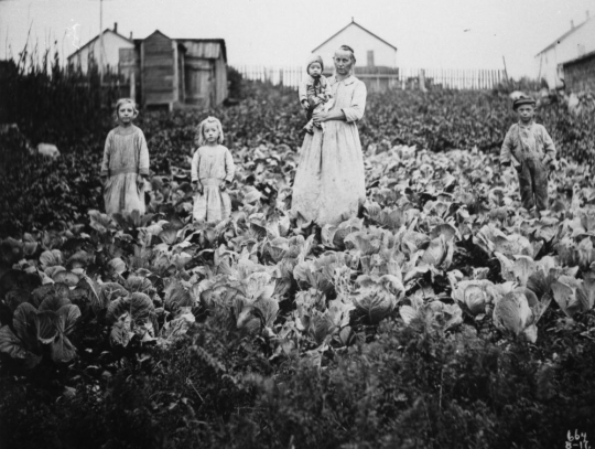
In 1866, state geologist Henry Eames confirmed the discovery of gold, silver, and iron deposits in Bois Forte, and the Vermilion Gold Rush began. Miners and settlers cut through woods and swamps using Ojibwe travel routes from Duluth to Lake Vermilion. Minnesota’s governor, Stephen Miller, asked the Commissioner of Indian affairs to remove the people of Bois Forte from the potentially valuable land around the lake, forcing them to move to a new reservation at Nett Lake. By May of 1866, Winston City was established on the south shore of Pike Bay with a sawmill, fourteen houses, mines, and three stamp mills. When the gold never materialized, this settlement became the area’s first ghost town.
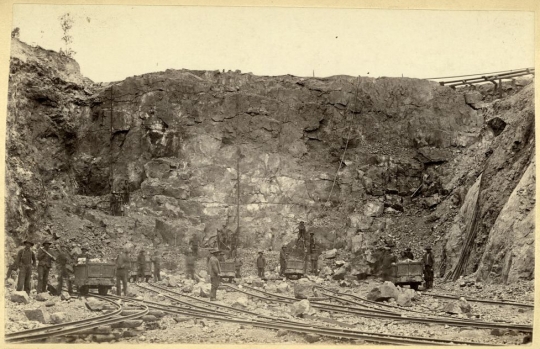
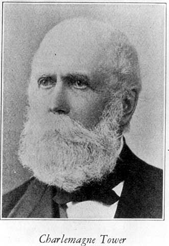
American interests in the Vermilion Range shifted to iron ore as Pennsylvania lawyer and businessman Charlemagne Tower funded an expedition in 1875. He acquired extensive lands in the area, bought the Duluth and Iron Range Railway, and founded Minnesota’s first commercial iron mine, spurring the growth of his namesake city (Tower). More than sixty other iron mining companies incorporated in Minnesota between 1887 and 1889, most of them on the Vermilion Range.
Most of the wealthier people on the Vermilion Range—professionals, business owners, mining executives—initially lived in Tower. Soudan was intended to serve as a residential location for workers. There were no commercial establishments; beyond housing there were a mine hospital, a school, churches, a club house, and a Finnish temperance hall. Ely became the largest community on the Vermilion Range, with a population that peaked in 1930 at 6,150 citizens.
Alongside the mining industry, logging shaped the local economy and landscape. Commercial logging began on Rainy Lake in the 1880s, and the first sawmill opened in Tower in 1884. The Knox Lumber Company incorporated in 1893 and focused operations east of Ely. Within two years, 300 people had formed the settlement of Winton next to the sawmill running on Fall Lake. Dams were constructed on Rainy and Namakan Lakes in 1910, launching the pulpwood industry.
After World War I, the workforce in the mines on the Vermilion Range had declined significantly. Electrifying and mechanizing underground mining had addressed labor shortages during the war itself and now served as a cost-saving measure for companies. Soudan was permanently mechanized in 1924, making the labor of individual miners less important.
Travel and outdoor recreation boomed in post-World War II America, with rising incomes and greater leisure time for the growing middle class. Federal legislation going back to 1902 had supported protecting large sections of land in and adjacent to the Vermilion Range district. Tourism near the Superior National Forest became a vital and growing source of income. By 1964, the Boundary Waters Canoe Area Wilderness (BWCAW) had received additional federal protection, while the Soudan Mine in Tower had ceased operations and been converted into a state park. The last mine on the Vermilion Range closed in 1967.
Economic officials in Ely tried attracting new industry to town while simultaneously adapting the area for a new service and tourism economy. Wages in the service industry, however, did not equal that of mining. Environmental regulations (such as the 1949 prohibition of air travel into the boundary waters) aided some aspects of the tourism industry while styming others. By the 1970s, the perception that urban environmentalists from the Twin Cities did not care about local livelihoods was well established. The 1964 Wilderness Act and related efforts were referred to as “class legislation” by Stan Pechaver, secretary of the Ely Chamber of Commerce.
By the early twenty-first century, tourism influenced by nature conservation was at the heart of the area’s economy. The Bois Forte Band of Chippewa ran a successful resort, casino, and golf course at Fortune Bay, which was one of the area’s largest employers in Tower. The Dorothy Molter Museum, the International Wolf Center, and Lake Vermilion-Soudan Underground Mine State Park served as principal attractions surrounded by protected lands in the Superior National Forest, BWCAW, and Voyageurs National Park.
In 2012, Twin Metals Minnesota sought to renew mineral leases on copper and nickel mining in the Rainy River basin, renewing a generations-old debate about who has the right to use the lands surrounding the Vermilion Range. On one side, new mining ventures promised good-paying jobs to a community in need of them. On the other, they threatened to pollute water in federally protected lands and the Bois Forte reservation, as well as discourage nature-based tourism. Local communities were divided over the prospect, and attempts to build a new mine failed to clear regulatory hurdles.

Alanen, Arnold R. “From Tower to Soudan: Townsites and Locations on the Vermilion Iron Range.” In Entrepreneurs and Immigrants: Life on the Industrial Frontier of Northeastern Minnesota, edited by Michael G. Karni. Chisholm, MN: Iron Range Research Center, 1991.
Buffalo Point First Nation. History.
https://www.buffalopoint-firstnation.ca/history
Eliseuson, Michael. Tower Soudan: The State Park Down Under. St. Paul: Minnesota Parks Foundation, 1976.
Ely Folk School and Bois Forte Band of Ojibwe. “Bois Forte Native Names Map.”
https://elyfolkschool.org/bois-forte-native-names-map-project
Forgrave, Reid. “In Northern Minnesota Two Economies Square Off: Mining vs. Wilderness.” New York Times magazine, October 12, 2017.
https://www.nytimes.com/2017/10/12/magazine/in-northern-minnesota-two-economies-square-off-mining-vs-wilderness.html
Fortune Bay Resort Casino. “Fortune Bay Celebrates 35 Fantastic Years!” October 28, 2021.
https://fortunebay.com/index.php/blog/fortune-bay-celebrates-35-fantastic-years
Harvey, Mark. "Sound Politics: Wilderness, Recreation, and Motors in the Boundary Waters, 1945–1964." Minnesota History 58, no. 3 (Fall 2002): 130–145.
https://storage.googleapis.com/mnhs-org-support/mn_history_articles/58/v58i03p130-145.pdf
Helland, John. “Chronology of Historical Actions for Boundary Waters Canoe Area Wilderness within Minnesota’s Superior National Forest.” Minnesota House of Representatives Information Brief, October 2004.
http://www.house.leg.state.mn.us/hrd/pubs/bwcawild.pdf
Hillman, Mike. “Forty Years Ago, The Pioneer Mine Shut Down.” Timberjay, March 24, 2007.
http://www.timberjay.com/stories/forty-years-ago-the-pioneer-mine-shut-down,3199
Lamppa, Marvin G. “From Art to Science: Mining at Soudan (1882–1924).” In Entrepreneurs and Immigrants: Life on the Industrial Frontier of Northeastern Minnesota, edited by Michael G. Karni. Chisholm, MN: Iron Range Research Center, 1991.
——— . Minnesota’s Iron Country: Rich Ore, Rich Lives. Duluth: Lake Superior Port Cities, 2004.
Manuel, Jeffrey T. Taconite Dreams: The Struggle to Sustain Mining on Minnesota’s Iron Range, 1915–2000. Minneapolis: University of Minnesota Press, 2015.
Minnesota Legislative Reference Library. Minnesota Issues Resource Guide. “Copper-Nickel Studies and Non-ferrous Mining.”
https://www.lrl.mn.gov/guides/guides?issue=coppernickel
Queenan, Anne. “Minnesota’s Newest State Park: Lake Vermilion–Soudan Underground Mine State Park.” Quetico-Superior Wilderness News, November 29, 2019.
https://queticosuperior.org/lake-vermilion-state-park
Richner, Jeffrey. People of the Thick Fur [sic] Woods: Two Hundred Years of Bois Forte Chippewa Occupation of the Voyageurs National Park Area. Lincoln, NE: United States Department of the Interior, National Park Service, Midwest Archeological Center, 2002.
Available at the Minnesota Historical Society library as E99.C6 R53 2002.
Soudan Underground Laboratory, University of Minnesota. Lab History: Why Underground?
https://www.soudan.umn.edu/background/index_2.shtml
Walker, David A. Iron Frontier: the Discovery and Early Development of Minnesota’s Three Ranges. St. Paul: Minnesota Historical Society Press, 1979.
 |
 |
 |
 |
 |
 |
 |
 |
 |
 |
 |
 |
 |
 |
 |
 |
 |
 |
The Soudan Mine closes in 1962 and reopens as a state park. The land’s reuse signals a fundamental shift in the Vermilion Range’s economy from one dominated by the mining industry to one that looks to tourism as its base.
Cree and Assiniboine leaders tell French Canadian military officer Pierre Gaultier de Varennes of “several iron mines with ores of different colors” as part of the Council at Fort St. Charles on Pikwedina Sagainan (Lake of the Woods).
A treaty between the United States and the Bois Forte Ojibwe is ratified on April 26. The treaty cedes lands at Onamuni Zaaga’iganiin (Vermilion Lake) and establishes a reservation at Asabiikone-Zaagai’iganiing (Nett Lake).
On July 31, Albert Chester identifies deposits of hard hematite on the Vermilion Range by drilling and blasting to reveal ore with iron percentages as high as 67 percent.
Charlemagne Tower and Samuel Munson sign a contract with George Stone on January 26 to purchase up to 8,000 acres near Lake Vermilion, with Stone agreeing to oversee labor and equipment needed to start mining operations.
On July 31, the “Three Spot” locomotive travels from Agate Bay to Tower and back with the first shipment of ore from the Vermilion Range via the freshly completed Duluth and Iron Range Railway track.
477,440 acres of cutover land east of Winton is withdrawn from public entry on June 30. Geological surveyor Edward Branff states, “The lands contain no timber. . .no one cares much what becomes of them.”
Superior National Forest is established on February 13. Forest rangers adapt existing structures for nature-based tourism by, for example, converting abandoned logging camps into fishing camps.
On December 17, President Harry S. Truman signs an order prohibiting flights below 4,000 feet over the area now known as the BWCA. Enforcement begins on January 1, 1951.
Soudan Mine—Minnesota’s oldest and deepest iron mine—ceases operations on December 15. The last shipment from its stockpile ships in August 1963, and the land becomes a state park.
Congress passes the Wilderness Act and the BWCA becomes part of the National Wilderness system, with a clause allowing for some logging and use of motors.
On April 1, the Pioneer Mine (Ely) ceases operations as the last remaining iron mine of the Vermilion Range.
Marvin Marshake (a physicist from the University of Minnesota) begins an underground lab to detect proton decay in the Soudan Mine after taking a tour.
The Bois Forte Band of Chippewa opens the Fortune Bay Bingo Casino on the shores of Lake Vermilion in August.
On June 8, the State of Minnesota acquires 3,034 undeveloped lands from US Steel to create Lake Vermilion State Park.
In January, the US Department of the Interior announces a twenty-year moratorium on mining in the Boundary Waters watershed, effectively preventing the Twin Metals copper-nickel mining from moving forward.
Made possible by the Arts and Cultural Heritage Fund through the vote of Minnesotans on November 4, 2008. Administered by the Minnesota Historical Society.
Minnesota Historical Society • 345 W. Kellogg Blvd., St. Paul, MN 55102-1906 (Map) • 651-259-3000 © MNHS.
Send questions or comments to mnopedia![]() mnhs [dot] org. View our Privacy Policy.
mnhs [dot] org. View our Privacy Policy.